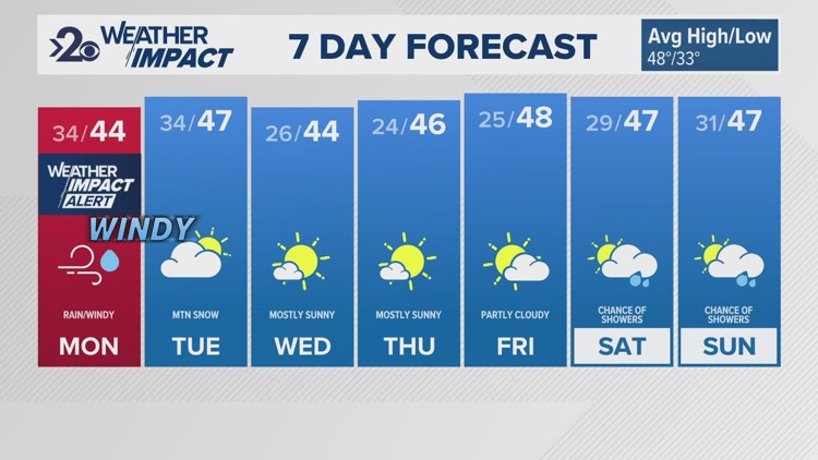
SPOKANE, Wash. — Monday will be a Weather Impact Alert Day across the Inland Northwest due to a push of high winds, rain, and heavy mountain snow. The wind will be the main priority as gusts upwards of 50mph are possible which could lead to tree damage and power outages.
The storm dropping into the Inland Northwest will blast through by Monday midday. The cold front passes through around 12pm meaning most of the rain will be before that, most of the wind will be after that moment.
Starting with the rain and mountain snow... Light rain is beginning across central and eastern Washington this morning. A heavier push of rain will be felt between 10am and 2pm for a majority of the area right as the cold front passes through. Snow levels are about 3,500' and the mountains of northeastern Washington and North Idaho will get another batch of snow at higher elevations. This has prompted Winter Weather Advisories and Winter Storm Warnings for the area mountain. Lookout Pass will be the stretch of road hit most heavily by snow due to the passing snow.
Now for the winds... wind gusts will start to increase after 12pm or so, in line with the cold front passage, and hitting their maximum this evening between 5pm and midnight. High Wind Warnings go into effect starting at 1pm for central Washington and Wind Advisories go into effect starting at 1pm for the Palouse and southern Washington. Moses Lake, Wenatchee, Chelan, and the Waterville Plateau will experience the strongest wind gusts upwards of 50mph, possibly peaking near 60mph today. For Pullman, winds speeds up to 45mph are likely, which is enough to cause some damage.
Meanwhile, Spokane and Coeur d'Alene are not under either alert, which wind speeds forecast around 40mph, just below the Wind Advisory threshold. That could change, and everyone in this area should know that it's still going to be quite windy. But the risk for damage is much lower.
At these speeds, tree damage and power outages are possible, especially above 45mph. The stronger the winds, the more likely the impacts will be realized. At 60mph wind gusts, that is considered severe and uprooted trees are possible, which would lead to a lot more damage and/or power outages.
The high winds will start to ease after midnight, and should not be severe on Tuesday. But breezy winds around 20-25 mph are still going to linger through the day.
Temperatures all this week will be in the mid- to upper- 40s.
Tuesday through Friday will be tame and dry with sunny skies each day. The weekend ahead will feature the next chance for rain after today.
- KREM 2 Meteorologist Thomas Patrick
Get the latest Weather Impact forecast and warnings on your mobile device. Download the KREM 2 app and turn on severe weather alerts.
About the KREM 2 Weather Team
- Jeremy LaGoo is the KREM 2 Chief Meteorologist, He joined KREM in October of 2020. You can watch Jeremy weeknights on KREM 2 News at 4, 5, 6, 10 and 11 p.m.
- Thomas Patrick is the Up with KREM meteorologist from 5-9 a.m. and noon. Thomas joined KREM in January 2019. Thomas is an AMS Certified Broadcast Meteorologist since 2015. He also serves as a KREM 2 weather and science reporter.
- Michelle Boss joined the KREM 2 weather team in 1999 and can be seen on the weekend evening forecast. She previously worked as a meteorologist at WEHT in Evansville, IN, and WOWT in Omaha, NE.
DOWNLOAD THE KREM SMARTPHONE APP
DOWNLOAD FOR IPHONE HERE | DOWNLOAD FOR ANDROID HERE
HOW TO ADD THE KREM+ APP TO YOUR STREAMING DEVICE
ROKU: Add the channel from the ROKU store or by searching for KREM in the Channel Store.
Fire TV: Search for "KREM" to find the free app to add to your account. Another option for Fire TV is to have the app delivered directly to your Fire TV through Amazon.
To report a typo or grammatical error, please email webspokane@krem.com.


