Tropical disturbance 92L to bring rain, wind, rip currents to Southeast coast
There is also an area in the southern Gulf of Mexico, in the same area as where Alberto got its start, that is being monitored for development.

Invest 92L could become short-lived tropical depression as it eyes Florida Friday
Invest 92L continues to approach the Florida and Georgia coast with heavy showers and thunderstorms, along with dangerous surf and rip currents, and forecasters say the storm may develop into a tropical depression.
Fresh off Alberto – the first named storm of the 2024 Atlantic hurricane season – forecasters are tracking two more areas of possible tropical trouble through the weekend.
Alberto made landfall in Mexico as a tropical storm Thursday morning after battering Texas with heavy rain and storm surge flooding on Wednesday. It has since dissipated.
Now, two other systems also have the potential to impact the U.S. over the coming days.
Here’s a closer look at the two other areas of interest in the tropics.

(FOX Weather)
Invest 92L could develop before reaching Southeast coast
A small area of low pressure located 80 miles east-southeast of Burnswick, Georgia continues to produce a concentrated area of showers and thunderstorms Friday afternoon with wind gusts of 35 mph. The latest Hurricane Hunters flight indicates a more well-defined circulation center, but the storm is still not quite organized enough to be considered a tropical cyclone, the National Hurricane Center (NHC) said in their 2 p.m ET update.
But the storm will only need a small increase in organization to upgrade to a short-lived tropical depression as it moves west-northwestward at 10-15 mph and approaches the northeastern coast of Florida or the Georgia coast later Friday.
 Image 1 of 3
Heavy surf pounds Jacksonville Beach, Florida on June 21, 2024. ( )
 Image 2 of 3
Heavy surf pounds Jacksonville Beach, Florida on June 21, 2024. ( )
 Image 3 of 3
Heavy surf pounds Jacksonville Beach, Florida on June 21, 2024. ( )
In the meantime, the NHC has dubbed this system Invest 92L. Invest is a designation given to an area of interest that allows forecasters to run specialized computer models to obtain more information on the system.
"Even if the circulation gets a little stronger, it’s going to want to pull in more dry air," said FOX Weather Hurricane Specialist Bryan Norcross. "And that’s going to inhibit its development and that’s one of the reasons we don’t think it will quickly strengthen or even has much of a chance of being very strong by the time it gets to the coast."

Dangerous rip currents stretch up and down the southern Atlantic coast
Tropical activity is bringing some heavy surf and a high risk of rip currents. Jacksonville ocean rescue crews tell FOX Weather how best to stay safe.
It currently has a medium chance of development before pushing ashore on Friday.
"The system is expected to reach the coast of northeastern Florida or Georgia by tonight, and interests there should monitor its progress," the NHC said.
Regardless of development, the system will bring periods of heavy rain, high surf and dangerous rip currents.
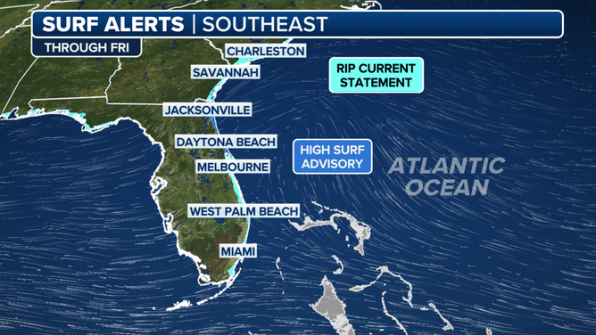
Southeast High Surf Alerts
(FOX Weather)
"This weather system has created big surf, very strong along-shore currents and strong rip currents," Capt. Rob Emahiser with Jacksonville Beach Ocean Rescue told FOX Weather. "And these conditions are really only for expert ocean swimmers. If you're not experienced in the ocean, then this would be a great time to watch it and stay dry."
If you do brave the waters, Emahiser says make sure you go in near a lifeguard. "It's well worth taking advantage of that free expert rescuer. That can help keep you safe," he said. "And then also pay attention when they whistle or trying to advise you of dangerous areas. Please heed that warning… We have had several cases where we have to go and assist people out of the water (Friday) but no major rescues yet today, knock wood."
A High Surf Advisory is up for the East Coast of Florida. Some gusty, onshore winds of 30-40 mph will also be possible.
HURRICANE EXPERTS PUSH FORWARD WITH AGGRESSIVE FORECAST DESPITE SLOW START TO SEASON

(FOX Weather)
Southwestern Gulf of Mexico being watched again
A broad area of low pressure is forecast to develop on Friday over southeastern Mexico and northern Central America.
The NHC said that environmental conditions appear conducive for gradual development of this system once it moves over the Bay of Campeche in the southwestern Gulf of Mexico on Saturday. It could become a tropical depression over the southwestern Gulf this weekend while it moves slowly west-northwestward or northwestward.
It currently has a medium chance of development in the next seven days.

(FOX Weather)