Know your zone: Texas hurricane evacuation zones
Millions of Texas residents live in an evacuation zone that stretches along waterways and the state’s hundreds of miles of coast. The coastline stretches from the Rio Grande to the Louisiana border.

Corpus Christi head of parks and recreation talks storm preps ahead of Hurricane Beryl
Robert Dodd joined FOX Weather to talk about how the popular coastal city is getting ready as Hurricane Beryl looms early next week.
HOUSTON - A threat from a tropical system could mean millions in the Lone Star State could be asked to evacuate, but being the second-most populous state in the country means finding evacuation routes and zones can be complicated.
Large hurricanes like Rita, Ike and Harvey forced millions of Texans to seek higher ground, resulting in hours of backups and delays along highways.
In fact, Hurricane Rita in 2005 triggered the largest pre-storm evacuation in the state’s history with 3.7 million residents who left their homes.
Emergency management agencies have compiled an interactive map for the most populated counties for residents to determine if their home or business is in an evacuation zone and find the nearest exit route.
For communities in South Texas, officials in the Brownsville and Corpus Christi metros have made alternative maps available.
The evacuation routes are meant to help guide residents to safer locations and away from threats that coastal cities face.
KNOW YOUR ZONE: FLORIDA EVACUATION MAP SHOWS WHO WILL HAVE TO LEAVE BEFORE A HURRICANE STRIKES
Properties that are under threat of being inundated or cut off by floodwaters are in an evacuation zone.
Typically, mobile homes, campgrounds and other similarly constructed facilities are among the first to receive evacuation orders, followed by zones nearest to the coast.
An easy-to-remember phrase used by emergency managers is that residents should "run from the water and hide from the wind."
Those in well-built structures, away from waterways, do not need to evacuate during hurricanes.
Flooding is the greatest killer during tropical cyclones due to the combination of torrential rainfall and a rise in the ocean, which can impact communities hundreds of miles inland and last for days after a tropical cyclone makes landfall.
According to a 2014 study by the National Hurricane Center leadership, nearly 90% of tropical cyclone deaths occur in storm surge, rainfall flooding or high surf.
WATER FROM HURRICANES, TROPICAL STORMS KILLS MORE IN US THAN WIND
The Lone Star State has established the State of Texas Emergency Assistance Registry, known as STEAR, for residents who may need assistance during a disaster.
Officials warn that the STEAR registry does not guarantee that individuals will receive services during an emergency, but it can help ensure that resources such as wheelchair-accessible buses or emergency transportation are sufficiently allocated.
To register, residents can apply online or by dialing 211 on any phone.
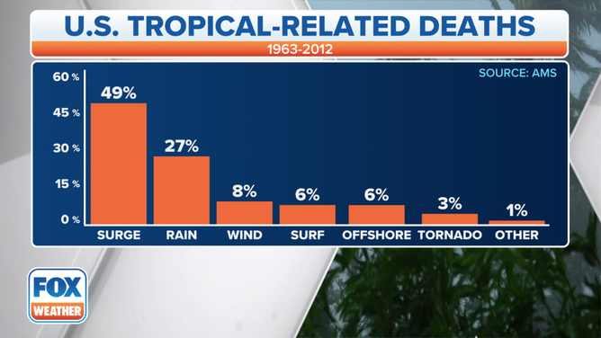
Cause of death in the United States directly attributable to Atlantic tropical cyclones between 1963-2012. (Data: Edward N. Rappaport, National Hurricane Center)
(FOX Weather)