

Live Helene updates: At least 11 dead in Georgia as tropical storm continues path
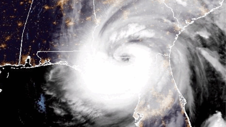
ATLANTA - Tropical Storm Helene continued its onslaught through Georgia Friday, with more than a dozen people dead across multiple states after the storm made landfall in Florida’s Big Bend region late Thursday night as a monster Category 4 hurricane with winds of 140 mph.
At least 21 deaths have been reported so far, including 11 in Georgia, 7 in Florida, 1 in North Carolina and 2 in South Carolina, and officials fear that number could continue to climb.
Helene made landfall about 10 miles west-southwest of Perry, Florida, at 11:10 p.m. Thursday, and impacts have been felt across the Southeast and into portions of the mid-Atlantic as the monster storm pushed farther inland and began to weaken.
Helene brought tropical storm-force winds, heavy rains, lightning, and serious flooding to the north Georgia area.
Tropical Storm Warning, evacuations and rescues in Georgia
11:47 a.m.: Gov. Brian Kemp says 11 people have died so far in Georgia from causes related to Helene.
This is a quick leap from the six deaths reported earlier on Friday. Kemp did not immediately provide a breakdown of where and how all the deaths occurred, citing work to notify the victims' next of kin, but said that they all came from areas in the path of the storm.
Speaking at a press conference shortly before noon on Friday, Kemp called the situation after the Helene a "dangerous environment," saying one of the deaths was a first responder.
"The loss of life that we've seen - a lot of it has been by fallen trees because of the saturated ground," Kemp said. "We also have potential for flash flooding and the waters are going to continue to rise."
In Valdosta, 115 structures are heavily damaged that have people trapped inside, Kemp said.
"Our priority is getting to medical emergencies and facilities like hospitals and nursing homes and others that need critical help and don't have power," Kemp said.
Valdosta's South Georgia Medical Center is currently without power after a tree hit its generator. Georgia Power is working to install a replacement at this time.
He asked residents to remain weather-aware and try to stay at home as much as possible for the rest of the day.
Georgia DOT reports 152 road closures across the state and two interstate closures - I-16 in Lawrence County and I-20 outside of Augusta.
Crews are shifting to the South Georgia areas that have experienced the most damage, Kemp said.
Georgia officials are planning a water release at Lake Rabun to deal with heavy flooding and crews are working to evacuate residents.
11:13 a.m.: Flooding continues to cause problems in metro Atlanta despite the end to most of the rain.
In Sandy Springs, Morgan Falls Dam has completely flooded. Police are asking residents to avoid the area.
Clayton County reports that Forest Parkway between JG Glover Court and Sapphire Circle has flooded. Photos showed several feet of water surrounding a nearby business and submerging a semi-truck in the parking lot.
11:07 a.m.: Atlanta-based Delta Air Lines is examining conditions at southeastern airports as travelers deal with delays and cancelations caused by Tropical Storm Helene.
According to FlightAware, more than 1,200 flights have been canceled and 2,160 flights were delayed on Friday.
In a statement, a Delta spokesperson said, while more delays and cancelations are possible, the airline does not expect any spikes in the aftereffects of Helene.
The airline has issued a travel waiver for any customers traveling to or from any airports impacted by Helene.
11 a.m.: Tropical Storm Helene continues to cause Flash Flood Emergencies in metro Atlanta and the Carolinas.
The National Hurricane Center reports that the storm was about 105 miles north-northeast of Atlanta and 30 miles southwest of Bryson City, North Carolina.
Over the morning, the storm decreased in strength and now has maximum sustained winds of 45 mph. It has sped up on its path north and now is moving at 32 mph.
The Tropical Storm Warning and Storm Surge for the Georgia coast has been discontinued.
9:50 a.m.: Atlanta Mayor Andre Dickens praised the city's fire crews for their work rescuing stranded residents as Tropical Storm Helene hit the city.
The mayor said the firefighters had rescued dozens of people and pets around the city.
The mayor says the city's unhoused population has been given shelter in multiple recreation centers around the city.
Dickens cautioned residents to continue to be careful and safe as recovery efforts continue.
"Please stay at home," he said, pointing to the Flash Flood Emergency.
The city's 911 and 311 have seen about 1,000 phone calls over the last 24 hours. Dickens recommended residents call 311 if they see downed power lines or flooding.
More than 1 million customers were without power on Friday morning. Georgia Power officials expect that number to continue to rise.
Dickens said the city has not seen any deaths or serious injuries in connection with the storm.
9:30 a.m.: Atlanta residents are checking out the damage and trying to avoid the flooding caused by Tropical Storm Helene.
At Buckhead's Peachtree Park apartments, residents have begun dumping out buckets of water that the flooded creek left in their homes.
FOX 5 cameras spotted people rescuing stranded animals and examining the condition of their soggy belongings.
8:55 a.m.: A Clayton County deputy has been taken to the hospital after a tree fell on his vehicle on Friday morning.
Officials tell FOX 5 that the off-duty deputy was heading home from work when the tree came down on Highway 138.
The deputy was sent to the hospital for observation. He is expected to be fine, officials said.
The tree blocked part of the highway for hours as crews worked at the scene.
MORE: Watch: FOX Weather meteorologist rescues woman from rising floodwaters in Atlanta
8:30 a.m.: FEMA has announced that it is opening federal disaster assistance to dozens of Georgia counties due to the emergency conditions caused by Tropical Storm Helene.
President Joe Biden authorized FEMA to coordinate disaster relief efforts on Thursday.
The funding is available to state and local governments for emergency protective measures such as evacuation and shelter support.
8:22 a.m.: The rain from Tropical Storm Helene has caused the Chattahoochee River to flood its banks in Heard County.
The emergency manager of Heard County shared photos of the flooding with FOX 5's Alex Forbes.
8:08 a.m.: The number of deaths in Georgia caused by Tropical Storm Helene reportedly continues to climb as crews work to assess the damage across the state.
Laurens County EMA Director Bill Laird confirmed with WMAZ that two people died in separate incidents connected with the storm overnight.
According to Laird, one person died when a tree fell on their home. The other was reportedly killed in a car crash.
In Pierce County, fire officials told First Coast News that a firefighter had been killed when a tree fell on his vehicle while he was driving in Blackshear.
Officials have previously reported two deaths at a mobile home in Wheeler County and one in a car crash in Colquitt County.
One death was reported in Florida and another died in Charlotte, North Carolina.
8 a.m.: Tropical Storm Helene is now 80 miles east-northeast of Atlanta and slowly losing speed as it moves closer to South Carolina. The storm had maximum sustained winds of 60 mph and continued to head north at 30 mph.
7:54 a.m.: More than 1 million customers across Georgia are without power as Tropical Storm Helene continues to leave a trail of damage as it moves through metro Atlanta.
The majority of the outages are in the south and west of the Peach State.
Georgia Power reports that more than 680,000 of its customers are without power. Crews are working to repair the damage.
7:44 a.m.: Georgia Gov. Brian Kemp has signed a new executive order authorizing 1,000 Georgia National Guard troopers to help in the recovery after Tropical Storm Helne.
The order is in addition to 500 National Guard members already heading into the field from a previous executive order.
"As we continue to assess Helene’s impact throughout Georgia, our hardworking response teams across the state are tending to casualties, widespread power outages, property damage, and flooding," Kemp wrote on X.
7:21 a.m.: Another Flash Flood Emergency has been issued for DeKalb and Gwinnett counties until 1:15 p.m. The warning includes Mechanicsville, Tucker, Doraville, Chamblee, Clarkston, and Stone Mountain. The National Weather Service says this a particularly dangerous situation and residents should seek higher ground now.
7:12 a.m.: A Flash Flood Emergency has been issued for Midtown Atlanta, College Park, Hartsfield-Jackson, Forest Park, Riverdale, and Jonesboro.
This is the highest level of warning that can be issued for floods.
Officials say life-threatening flash flooding is occurring in low-water crossings, creeks and streams, and urban areas including highways, underpasses, and streets.
Residents should try to avoid driving as much as possible and stay away from areas of standing water.
7:09 a.m.: The Flash Flood Warning for Fulton, DeKalb, and Clayton counties has been extended to 1 p.m.
6:45 a.m.: A Flash Flood Warning is in effect for parts of Clayton, Cobb, DeKalb, Fayette, Fulton, Henry and Rockdale counties until 12:45 p.m. Officials say 4 to 6 inches of rain have fallen overnight and an additional 1 to 2 inches is expected throughout the morning.
6:16 a.m.: A family has been rescued after floodwaters trapped them in their car in Atlanta.
FOX 5 cameras were on the scene moments after the rescue on Bohler Road near Peachtree Battle Avenue.
The couple, their infant child, and two dogs were reportedly stranded on the top of their car.
Firefighters on the scene said the car had begun to float in the swift current left the roadway.
Crews were able to use boats and a system of ropes to get the family to dry land and into a waiting ambulance.
Thankfully, officials say everyone is fine.
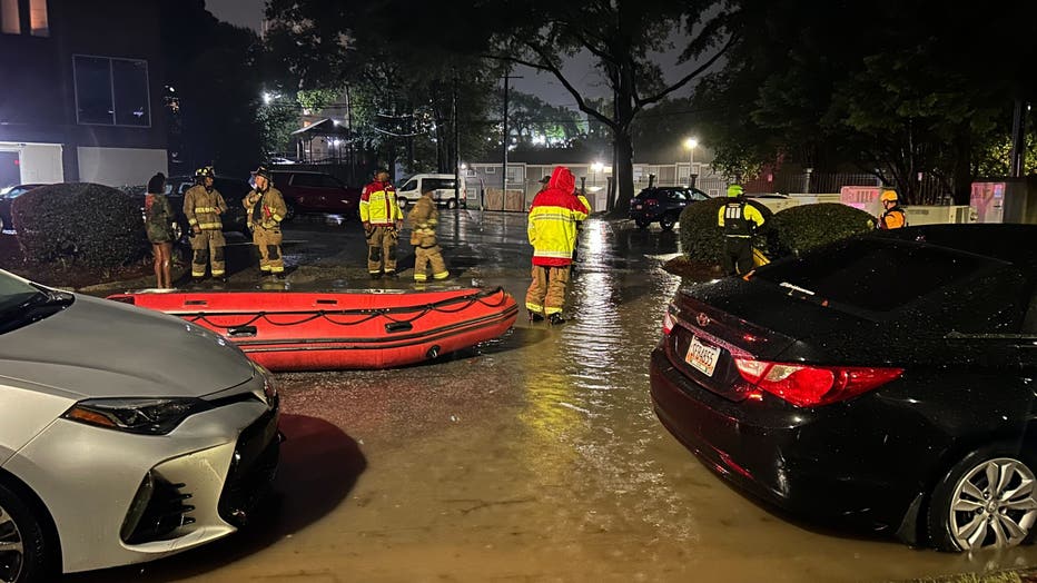
6 a.m.: Fire crews have rescued about 60 people from flooded apartments at Peachtree Park in Atlanta as Peachtree Creek continued to rise.
The city is using MARTA buses as temporary shelters for residents who had to evacuate their homes to escape the floodwaters.
Residents told FOX 5's Lindsay Tuman they woke up to find multiple feet of water in their apartments.
5:43 a.m.: A third death has been reported in Georgia connected to now-Tropical Storm Helene. Colquitt County Emergency Management reports that an individual has died after they crashed into a tree that had fallen overnight on 5th Avenue SE in Moultrie. Officials say they will begin assessments and cleanup after sunrise. The identity of the victim has not been released pending next of kin.
Two other deaths were reported on Thursday night in Wheeler County after a possible tornado destroyed a mobile home.
In Florida, officials reported one person had died after a sign fell onto their car on Interstate 4.
5:37 a.m.: A Flash Flood Warning is in effect for Cherokee, Cobb, Douglas, Fayette, Fulton, Bartow, Chattooga, Floyd, Gordon, Paulding, Walker, and Coweta counties until 11:30 a.m.
5:30 a.m.: Officials are asking Georgians to prepare for long-duration power outages and follow safety protocols with generators. If you use a generator after the storm, make sure it is placed at least 20 feet away from doors, windows, and garages to avoid carbon monoxide poisoning.
The number of Georgians without power continues to rise, with the latest numbers reporting more than 811,000 across the state.
5:23 a.m.: Brookhaven police have closed Kendrick Drive near Peachtree Road, Tryon Road at Cravenbridge Road, Hopkins Terrace near Briarcliff Road, and West Druid Hills Drive near Buford Highway.
A large tree has fallen on power lines and a vehicle on North Druid Hills Road at Lenox Park Boulevard. All lanes are blocked in both directions as officers wait for Georgia Power crews to respond. Drivers should avoid the area.
More than 784,000 customers are without power in Georgia. Most of the outages remain in southern Georgia, but the number of outages have been steadily increasing as Helene travels northward.
5:13 a.m.: The city of Atlanta has suspended all of its trash, recycling, and yard debris collection for Friday due to Tropical Storm Helene. Collection will resume on Saturday depending on weather conditions. Friday's service will be moved to Sunday. Officials are asking residents not to put solid waste items curbside during the storm.
5:07 a.m.: A Flash Flood Warning for Atlanta, Sandy Springs, and Roswell has been expanded until 7:15 a.m. Drivers should avoid flooded roads and move to higher ground as soon as possible.
4:58 a.m.: Helene has weakened to a tropical storm as it continues to head toward metro Atlanta. The National Hurricane Center reports that Helene is about 40 miles east of Macon and 100 miles southeast of Atlanta. The storm has winds of up to 70 miles per hour and is traveling north at 30 mph.
Weather officials say tornadoes are still possible over parts of east Georgia on Friday morning.
4:48 a.m.: The number of Georgia customers without power has leaped to more than 683,000.
A Tornado Watch remains in effect for Baldwin, Emanuel, Glascock, Hancock, Jefferson, Johnson, Laurens, Montgomery, Taliaferro, Toombs, Treutlen, Warren, Washington, Wheeler, Wilkes, and Wilkinson counties in central Georgia until 8 a.m.
4:25 a.m.: Fire crews used boars to rescue multiple families who were trapped in their homes near Peachtree Creek in northwest Atlanta.
FOX 5's Brooke Zauner saw submerged cars on Woodward Way near the creek.
Neighbors say it was very reminiscent of the catastrophic flooding that hit the area in 2009.
Along with Peachtree Creek, Nancy Creek at Rickenbacker Drive in Fulton County is reported to be in the Major Flood Stage.
4:12 a.m.: A Flash Flood Warning has been issued for Habersham and Rabun counties until 8 a.m. The National Weather Service reports between 3 and7 inches have fallen and additional rainfall of 1 to 3 inches is possible.
4 a.m.: Hurricane Helene is slowing down, but the amount of damage it can deal still remains high. The National Hurricane Center reports Helene was located about 100 miles southwest of Augusta and about 40 miles southeast of Macon. The storm was moving north at 30 mph and had sustained winds reaching up to 75 miles per hour. A University of Georgia weather station in Vidalia, Georgia recently reported a wind gust of 77 mph.
Officers have blocked off part of Lenox Road in Atlanta's Morningside neighborhood while they deal with two vehicles caught in a flooded part of the road.
On Brookhaven's Carter Drive, a fallen tree snapped power lines and left things in the dark. A Georgia Power crew was on the scene examining the damage but were not able to begin repairs.
Water rescues and evacuations continue at Peachtree Park in Atlanta over concerns of rising waters from Peachtree Creek.
While the flooding is the focus of concerns around metro Atlanta right now, the area is bracing for winds to pick up in the next few hours as the storm's bands pass through the area.
3:38 a.m.: More than 583,000 customers are without power in Georgia. That number is expected to jump up quickly as the storm moves northward toward the metro Atlanta area.
In Valdosta, the worst part of the storm is over, but the heavy winds have left nearly 100% of the area without power and damaged many buildings.
Crews say they will begin to work on restoring power as soon as it is safe to send out the bucket trucks.
3:30 a.m.: In Atlanta, firefighters responded to reports of a woman trapped inside her home by floodwaters.
The rescue happened at the CoHo Apartments on N Colonial Homes Circle, which is located close to Peachtree Creek in northwest Atlanta.
FOX 5's Brooke Zauner found firefighters at the scene and cars partly covered with water in the parking lot.

3 a.m.: The National Hurricane Center reports that Helene continues to produce hurricane-force winds as it moves deeper into Georgia. The hurricane is moving north-northeast at a speed of around 30 mph and is located about 75 miles north of Valdosta and 55 miles south-southeast of Macon.
Weather stations in Douglas, Georgia have reported wind gusts of 92 mph.
2:57 a.m. - Residents living near Nancy Creek in Sandy Springs are being evacuated as the waters rise.
2:50 a.m. - A Flash Flood Warning has been issued for Butts, Crawford, Monroe, Barrow, Cherokee, Clayton, Cobb, DeKalb, Fayette, Forsyth, Fulton, Gwinnett, Henry, Rockdale, Walton, Lamar, Pike, Spalding, Talbot, Taylor, and Upson counties until 5:15 a.m. Live VIPIR indicated heavy rain across the warned area. Between 2 and 4 inches of rain have fallen. The expected rainfall rate is 0.5 to 1 inch in 1 hour. Additional rainfall amounts of 1 to 3 inches are possible in the warned area. Flash flooding is ongoing or expected to begin shortly.
2:46 a.m. - Georgia Power reports 283,482 outages while Georgia EMCs report 258,618 outages, mostly in southern and Middle Georgia.
2:44 a.m. - A Flash Flood Warning for Habersham, Rabun, and Stephens counties has been extended through 6 a.m. Friday. FOX 5 Live VIPIR indicated heavy 2 inches per hour or greater rainfall rates pushing across the warned area. Many locations have already received in excess of 4 inches of rainfall today, with more rain on the way. Flash flooding is ongoing or expected to begin shortly across the warned area.
2:42 a.m. - Hall County reports 71 roadway incidents, including downed trees and traffic signal issues, since Wednesday evening.
2:40 a.m. - Briarcliff Road at Briarlake Road is closed due to flooding.
2:34 a.m - A Flood Warning has been issued for Sweetwater Creek near Austell affecting Douglas and Cobb counties until early Sunday morning. At 10.0 feet, Flood Stage is reached. Minor flooding occurs in the woodlands and fields upstream and downstream from the gauge near the Interstate 20 bridge. Portions of a paintball playing field just downstream of the bridge begin to flood. Athletic fields in Woodrow Wilson Park on Mount Vernon Road began to flood due to water backing up in ditches. At 13.0 feet, Moderate flooding began. Significant flooding occurs in the woodlands and fields upstream and downstream from the gauge near the Interstate 20 bridge. Portions of a paintball playing field just downstream of the bridge and athletic fields in the Woodrow Wilson Park on Mount Vernon Road are flooded with 2 to 3 feet of water. Water began to flood a few mobile homes on Brook Forest Road and homes on Wren Circle in Douglas County. Portions of Sunlight Drive in Cobb County will be flooded.
2:30 a.m. - A tree crashed on a home along Casplan Street in southwest Atlanta. Homeowner Yolanda Tamplin said there was no warning.
"We were just asleep, and we heard a big boom, and I heard my son on the other side saying he can't get out and my daughter was trapped inside in her room, but my son was able to get her out," she explained. Firefighters had to break windows to get them out of the home.
2:12 a.m. - Fire crews are responding to the Peachtree Park Apartments in Atlanta after reports that the adjacent Peachtree Creek is rising. One resident told FOX 5 they woke up to two feet of water in their apartment.
Atlanta Fire crews are responding to the Peachtree Park Apartments after the adjacent Peachtree Creek began to flood the area on Sept. 27, 2024. (FOX 5)
2:02 a.m. - Sandy Springs reports residents living near Nancy Creek are advised to evacuate to higher ground due to extreme flooding. The bridge near Windsor Parkway over Nancy Creek is closed. Detour to Peachtree Dunwoody Road to Peachtree Rd to Wieuca Rd to Roswell Road OR Peachtree Dunwoody Road NORTH to Glenridge Connector.
2 a.m. - The National Hurricane Center says Helene has been downgraded to a Category 1 with winds of 90 mph. It continues to move north-northeast at 26 mph. It was located about 30 miles north of Valdosta and about 185 miles south of Atlanta.
1:41 a.m. - Georgia Power reports 167,772 outages and Georgia's EMCs report 155,860 across the state.
1:29 a.m. - A Flood Warning has been issued for Big Creek below Hog Wallow Creek at Roswell affecting Fulton County until further notice. At 12.0 feet, Minor flooding continues to expand further into the woodlands and grassy areas along the creek upstream and downstream from the gage. Further downstream, where the creek merges with the Chattahoochee River, the Big Creek and Azalea parks near Roswell Road and along Riverside Road and Azalea Drive begin to flood. If the Roswell gage on the Chattahoochee River is 7.5 feet or higher, then the combination of flows will cause the access road to the Huntcliff horse stables across from Azalea Park to flood. At 10.0 feet, Flood Stage is reached. Minor flooding of woodlands and grassy areas begin along the creek upstream and downstream from the gage off Oxbo Drive in the Roswell area. Also high water continues to encroach into the Big Creek Park two miles downstream along Roswell Road and Riverside Road. If the Roswell gage on the Chattahoochee River is 8 feet or higher, then the combination of
flows will cause the access road to the Huntcliff horse stables across from Azalea Park to begin to flood.
1:24 a.m. - The Flood Warning for Peachtree Creek in Atlanta affecting DeKalb and Fulton counties has been upgraded to a Major flooding event. The warning is in effect until late Friday afternoon. At 23.0 feet, A massive flood occurs with the water flowing over Northside Drive. Numerous evacuations are needed as many homes, businesses, and apartments will be flooded with several feet of water along Peachtree Park Drive, Fairhaven Circle, Peachtree Memorial Drive, Biscayne Drive, North Colonial Homes Circle, Haven Ridge Drive, Alton Road, Woodward Way, Sagamore Drive, Oldfield Road, Peachtree Battle Avenue and Circle, Bohler Road, Hanover West Drive and Battleview Drive. Wesley Drive remains flooded.
1:23 a.m. - A Flash Flood Warning Harris, Meriwether, Pike, Talbot, Troup, and Upson counties until 7:30 a.m. FOX 5 Live VIPIR indicated heavy rain across the warned area. Between 2 and 4 inches of rain have fallen. Additional rainfall amounts of 1 to 2 inches are possible in the warned area. Flash flooding is ongoing or expected to begin shortly.
1:20 a.m. - Hurricane Helene continues to pose serious threats across Georgia as it works its way up from Florida. The National Weather Service has issued a series of Flash Flood Warnings, with heavy rains expected to persist for several hours.
FOX 5 Storm Team Chief Meteorologist David Chandley reported that the storm is moving quickly and continues to cause significant trouble across northern Georgia. "Buckle up," Chandley warned. "We’ve got numerous flash flood warnings in northeast Georgia and across metro Atlanta. Flooding is already ongoing, and it’s only going to get worse."
Areas such as Cobb, Paulding, and Bartow counties are experiencing heavy downpours, with rainfall totals reaching 2 to 4 inches in just the last 12 hours. Flash Flood Warnings have been issued for both Georgia and the upstate region of South Carolina.
The center of Hurricane Helene made landfall near the Georgia-Florida line early this morning, with the eye of the storm near Valdosta. The storm is moving north, expected to follow I-75 toward north Georgia as the day progresses. Additional rainfall of 2 to 5 inches is expected across much of the state, with some areas already reporting totals as high as 8 inches.
In addition to flooding concerns, widespread power outages are being reported across southern Georgia.
The wind damage is a growing concern, particularly in areas like Valdosta and along Georgia's coastline. "We’re going to continue to monitor wind speeds, but as of now, we’ve seen gusts over 70 miles per hour in many areas. These winds will continue to be a problem as Helene makes its way north," FOX 5 Storm Team Meteorologist Alex Forbes said.
In Atlanta, downed trees have already caused significant damage. A tree fell onto a home on Palisade Road in Buckhead, and reports of fallen trees continue to come in across Fulton County. Emergency shelters have been opened in DeKalb and Douglas counties for residents needing safety from the storm. The Emergency Operations Center in Douglas County remains active, monitoring conditions.
The situation remains fluid, and officials are urging residents to stay off the roads and remain indoors. With flooding and wind conditions expected to worsen into the night, the primary concern continues to be the safety of residents in affected areas.
FOX 5’s Christopher King, reporting live from northeast Atlanta, reiterated that the situation remains dangerous: "Flooding is ongoing, and with more rain and wind to come, we expect conditions to deteriorate further."
Residents are advised to stay tuned to local updates and weather warnings as the storm continues its path through the region.
1 a.m. - A beaver is taking a midnight dip in what should be a roadway, but is now Peachtree Creek.
12:58 p.m. - A Flash Flood Warning has been issued for Chattahoochee, Harris, and Muscogee counties until 7 a.m. Friday. FOX 5 Live VIPIR indicated heavy rain across the warned area. Between 2 and 4 inches of rain have fallen. Additional rainfall amounts of 1 to 2 inches are possible in the warned area. Flash flooding is ongoing or expected to begin shortly.
12:44 a.m. - Waterways across north Georgia are beginning to overflow as rains from the outer bands of Hurricane Helene continue to dump steady rain over the area. FOX 5 crews at Peachtree Creek in Atlanta have seen the water steadily rise over the last few hours.
12:39 a.m. - Valley View Road is currently closed due to a downed tree, Dunwoody police reported
.
12:38 a.m. - A Flash Flood Warning has been issued for Habersham, Rabun, and Stephens counties until 3 a.m. Friday. FOX 5 Live VIPIR indicated heavy 2 inch per hour or greater rainfall rates pushing across the warned area. Many locations have already received in excess of 4 inches of rainfall today, with more rain on the way. Flash flooding is ongoing or expected to begin shortly across the warned area.
12:35 a.m. - The eye of Hurricane Helene approaches the Florida-Georgia line as it treks northward into the Peach State.
The eye of Hurricane Helene approached the Florida-Georgia line on Sept. 27, 2024. (NOAA)
12:34 a.m. - A Flood Warning has been issued for the Chattahoochee River in Atlanta affecting Fulton and Cobb counties until late Friday morning. At 14.0 feet, Flood stage is reached. Minor flooding begins in the woodlands along the river upstream and downstream from the gage on Paces Ferry Road. Portions of an athletic field at Lovett School...backyards of residential homes on Cochise Drive, Paces Ferry Drive, Paces Manor and Farmington Drive, and walking paths by a restaurant will be under one foot of water.
12:30 a.m. - Power goes out in Valdosta as Helene treks north into Georgia.
12:28 a.m. - A Flood Warning has been issued for the South River at Flakes Mill Road near Atlanta affecting DeKalb County until Friday evening. At 15.0 feet, Minor flooding continues to expand further into the woodlands along the river upstream and downstream from the gage on Flakes Mill Road. Large portions of the Chapel Parkwest of the gage will be under 2 to 3 feet of water. At 19.0 feet, Moderate flooding begins. Significant flooding expands further into the woodlands along the river upstream and downstream from the gage on Flakes Mill Road. The Chapel Park west of the gage will be completely flooded. The flood waters will cover low portions of the service road leading to the Snapfinger Advanced Wastewater Treatment Facility...and affect the parking lots south of the administration building on the property. Flooding begins in backyards of homes on Roundtable and English Valley Drives.
12:27 a.m. - The Oconee County Sheriff's Office reports both lanes of Inner loop between exits 4 and 1 are shut down due to an accident. Avoid the area.
12:26 a.m. - Georgia Power reports 89,420 outages and Georgia EMCs report 73,405 outages across the state.
12:20 a.m. - Winds have begun to pick up in Valdosta. MORE
12:10 a.m. - A Flood Warning has been issued for the Chattahoochee River at US 41 in Atlanta affecting Fulton and Cobb counties until further notice. At 14.0 feet, Flood stage is reached. Minor flooding occurs in the woodlands and portions of the Chattahoochee National Recreation Area along the river upstream and downstream from the gage on Cobb Parkway. The flood waters will reach the top of the concrete boat ramp in the recreation area.
12:03 a.m. - A strong thunderstorm will impact portions of southwestern Rockdale, southwestern DeKalb, central Henry, south central Fulton, northern Clayton and west central Newton Counties through 12:30 a.m. A strong thunderstorm was over Kelleytown, or near McDonough, moving northwest at 35 mph. It had 40 mph winds and heavy rain.
12 a.m. - Helene's eyewall is moving extremely quickly over the Florida Panhandle and is taking aim at southern Georgia.
11:57 p.m. - A Flood Warning has been issued for Alcovy River at New Hope Road near Grayson affecting Walton and Gwinnett counties until late Friday morning. At 9.0 feet, Flood stage is reached. Minor flooding begins of the woodlands upstream and downstream from the river gauge at New Hope Road. At 11.0 feet, Moderate flooding begins. Significant flooding expands further into the woodlands upstream and downstream from the river gauge at New Hope Road. The water level reaches the bottom of the bridge. County officials may need to close the bridge due to erosion to the banks on the sides of the bridge.
11:55 p.m. - The city of Atlanta says Lake Forrest Drive NE is currently closed from Barbara Lane NW to Chastain Park Drive NW (formerly West Wieuca Road NW) due to storm-related impacts in the area. The closure will remain in effect until further notice.
11:50 p.m. - The Spalding County Sheriff's Office reports the following roads are closed:
- O’Dell Rd (Lakeshore)
- School Rd (475-500)
- Moon Road ( Bridge Closed )
- Scott Branch Rd (flooding)
11:36 p.m. - A Flash Flood Warning has been issued for Clayton, Cobb, DeKalb, and Fulton counties until 5:30 a.m. Friday. FOX 5 Live VIPIR and automated rain gauges indicated heavy rain falling across the warned area. Between 2 and 4 inches of rain have fallen. The expected rainfall rate is 1 to 3 inches in 1 hour. Additional rainfall amounts of 1 to 3 inches are possible in the warned area. Flash flooding is ongoing or expected to begin shortly.
11:34 p.m. - A Flood Warning has been issued for Nancy Creek at West Wesley Road at Atlanta affecting Fulton County until further notice.
11:32 p.m. - Helene is expected to bring "unprecedented wind and flooding impacts" to north Georgia through Friday, the National Weather Service reports.
11:27 p.m. - A strong thunderstorm will impact portions of south central Rockdale, central Henry, Butts and southwestern Newton counties through midnight. The storm, located over Stark near Jackson, was moving northwest at 25 mph.
11:23 p.m. - A Flash Flood Warning has been issued for Cherokee, Cobb, Douglas, Fayette, Fulton, Gilmer, Pickens, Bartow, Carroll, Gordon, Murray, Paulding, and Coweta counties until 5:30 a.m. Friday. FOX 5 Live VIPIR indicated heavy rain falling across the warned area. Between 1 and 3 inches of rain have fallen. The expected rainfall rate is 1 to 2 inches in 1 hour. Additional rainfall amounts of 1 to 3 inches are possible in the warned area. Flash flooding is ongoing or expected to begin shortly.
11:20 p.m. - Hurricane Helene has made landfall near Perry, Florida in the Big Bend region. It continues to move inland, north-northeast at 24 mph.
11:11 p.m. - Two people were killed in a possible tornado in south Georgia as Hurricane Helene approaches, Wheeler County Sheriff's Office reports. The likely tornado touched down near Hwy. 19 at Adams Cemetery Road, destroying a mobile home.

Peachtree Creek in Atlanta has overflown its banks as rain from the outer bands of Hurricane Helene pounded the area on Sept. 26, 2024. (FOX 5)
11:09 p.m. - A Flood Warning has been issued for Big Creek at GA-9 near Cumming affecting Forsyth County until further notice. At 6 feet, Flood stage is reached. Minor flooding will expand into the natural flood plain of the creek upstream and downstream from the gage at Atlanta Highway or Georgia Highway 9. Large portions of the sidewalk and boardwalk of the Big Creek Greenway will begin to flood. The areas under the Georgia 400 Highway and McFarland Road will be covered with around one foot of water. A portion of the sidewalk under Majors Road will be covered with around two feet of water.
11 p.m. - Hurricane Helene is very close to making landfall in Florida Big Bend, accompanied by catastrophic storm surge and life-threatening winds.
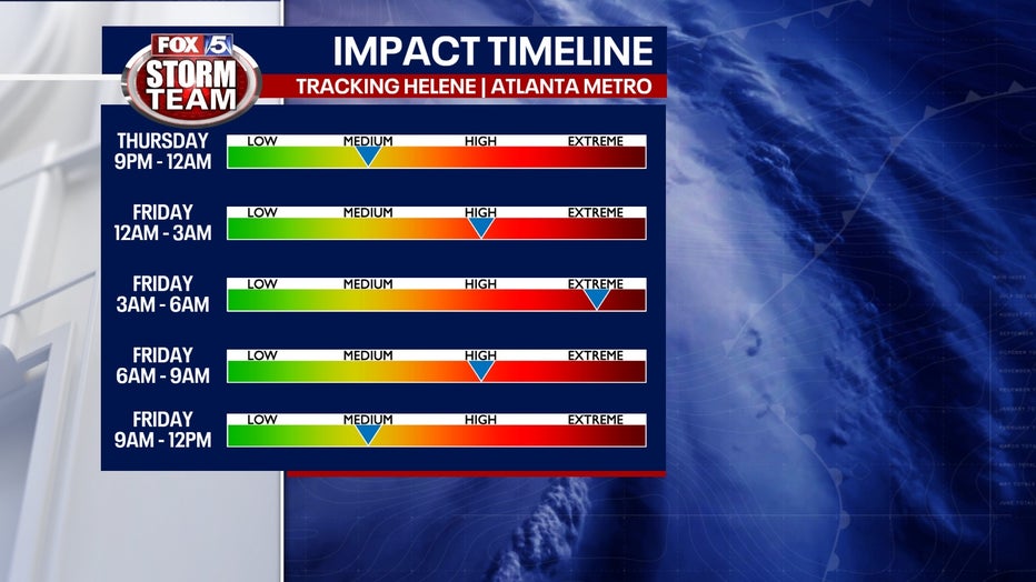
Meanwhile, north Georgia residents should be bracing for significant rainfall and strong winds. FOX 5 Storm Team Chief Meteorologist David Chanley indicated that the storm is expected to impact metro Atlanta early Friday morning, with the most intense weather likely occurring between 2 a.m. and 7 a.m.
Chanley warned of dangerous conditions, including heavy rainfall and potential flash flooding across northern Georgia. Preliminary reports show nearly two inches of rain have already fallen in the Atlanta area, with forecasts predicting an additional three to five inches through Friday morning. "The flooding is going to get worse," Chanley said.
Wind gusts have already begun to pick up, reaching as high as 50 mph in some areas. Officials are concerned about downed trees and power lines as winds increase throughout the night.
Flash flood warnings are currently in effect for several counties, particularly in the northern metro area and along the Georgia-South Carolina coast. The National Weather Service has urged residents to prepare for rapidly changing conditions and to remain vigilant as the storm progresses.
Meteorologists expect the worst of the storm to pass by noon on Friday, although rain and wind may linger into the weekend. While temperatures are projected to remain in the 70s, the potential for additional rain and wind will keep the region on alert.
10:57 p.m. - The Flood Warning for Nancy Creek at Rickenbacker Drive in Atlanta affecting DeKalb and Fulton counties has been upgraded. Major flooding begins with widespread flooding of residential property and around 25 homes upstream and downstream from the gage on Rickenbacker Drive. The water will be a few feet deep in the crawl spaces and walkout basements of homes on East Powder Horn Road and Hitching Post Trail around 1.5 miles upstream, along Rickenbacker Way near the gage, and the out buildings on Fairfield Drive around 2 miles downstream.
10:53 p.m. - Georgia Power reports 20,658 outages while the Georgia EMCs report 10,253 outages across the state.
10:39 p.m. - A Flood Warning has been issued for South Fork Peachtree Creek at Johnson Road in Atlanta affecting DeKalb and Fulton counties until Friday afternoon. Major flooding begins along the creek upstream and downstream from the gage on Johnson Road. Record flooding never seen before will inundate the backyards of the residential homes on Noble Drive, Helen Drive< and Kay Lane with up to 4 feet of water. The water level will reach the foundations of a few homes and may enter some crawl spaces. This height combined with the flow on North Fork Peachtree Creek will likely produce major flooding further downstream on Peachtree Creek in Fulton County.
10:32 p.m. - The Flood Warning for the Flint River at US 19 near Carsonville affecting Crawford, Talbot, Upson and Taylor counties through late Monday evening has been upgraded. The river is expected to rise above flood stage late Thursday night to a crest of 31.1 feet early Saturday morning. It will then fall below flood stage on Monday afternoon.
10:31 p.m. - The Flood Warning for Nancy Creek at Rickenbacker Drive at Atlanta affecting DeKalb and Fulton counties has been upgraded until Friday afternoon. Widespread flooding of residential yards and property occurs upstream and downstream from the gage on Rickenbacker Drive. The water will begin to enter crawl spaces and walkout basements of homes on East Powder Horn Road and Hitching Post Trail around 1.5 miles upstream...along Rickenbacker Way near the gage, and out buildings on Fairfield Drive around 2 miles downstream.
10:29 p.m. - The Flood Warning has been issued for the Hiwassee River at Riverside Drive near Hiawassee, affecting Towns County through Friday evening. Flooding continues to expand into fields and woodlands near the river. Several trailer homes in the Enchanted Valley Resort, around one mile downstream and on the right bank of the stream gage on Riverside Drive, will have water beginning to get into the homes. Access roads in the resort will begin to flood. Evacuations of some residents may be necessary. The water level will reach the bottom of the Riverside Drive bridge, and it may be closed by county officials.
10:25 p.m. - A Flood Warning has been issued for Potato Creek at County Line Road near Orchard Hill, affecting Lamar and Spalding counties until further notice. Minor flooding continues in the woodlands, fields, and pastures upstream and downstream from the gage on County Line Road.
10:25 p.m. - A Flood Warning has been issued for the Alcovy River at New Hope Road near Grayson, affecting Gwinnett and Walton counties until further notice. Minor flooding continues to expand further into the woodlands upstream and downstream from the river gauge at New Hope Road.
10:24 p.m. - A Flood Warning has been issued for Shoal Creek at Columbia Drive near Atlanta, affecting DeKalb County until further notice. Minor flooding will occur in the woodlands and natural flood plain of the creek upstream and downstream from the gage on Columbia Drive.
10:24 p.m. - A Flood Warning has been issued for Sweetwater Creek at Club Drive near Lilburn, affecting Gwinnett County until further notice. Minor flooding will occur in portions of the Northwood Country Club Golf Course upstream from the gage on Club Drive...and in the woodland areas downstream from the gage and for the next four miles until the creek merges with the Yellow River. An old concrete golf cart bridge around 300 feet downstream from the gage will begin to flood.
10:23 p.m. - A Flood Warning has been issued for Crooked Creek near Norcross affecting Gwinnett and Fulton counties until further notice. Minor flooding of the natural flood plain begins mainly on the left bank upstream and downstream from the gauge at Spalding Drive.
10:23 p.m. - A Flood Warning has been issued for Peachtree Creek in Atlanta, affecting DeKalb and Fulton counties. Moderate flooding is expected near Northside Drive. A parking lot near the corner of Peachtree Road and Fairhaven Circle begins to flood. Woodward Way will flood with 1 to 5 feet of water and reach the foundation of some homes that have not been elevated. Sections of Hanover West Drive and backyards on portions of Peachtree Battle Avenue will flood with 1 to 3 feet of water, and it will reach the foundation of some homes.
10:22 p.m. - A Flood Warning has been issued for North Fork Peachtree Creek at Buford Highway Atlanta affecting DeKalb and Fulton counties until further notice. This will impact homes along Victory Drive, Dunwoody Place, and Converse Drive with about 5 feet of water expected. The Sun Tan Center parking lot and an apartment parking lot will also be impacted. This height combined with the flow on South Fork Peachtree Creek will likely produce major flooding further downstream on Peachtree Creek in Fulton County.
10:21 p.m. - A Flood Warning has been issued for Snapfinger Creek near Decatur affecting DeKalb County until further notice. Minor flooding is expected, impacting woodlands and yards near the creek upstream and downstream from the gage on Redan Road. It will primarily affect locations off South Indian Creek Drive and Rowland Road upstream from the gage. Flooding will expand in the park near the creek next to Rowland Road and portions of Redan Road will have standing water due to poor drainage.
10:20 p.m. - A Flood Warning has been issued for Cobbs Creek at Rainbow Road near Decatur, affecting DeKalb County until further notice. It will impact residential yards and woodlands along the creek near Rainbow Drive. Floodwaters will be from one to two feet deep in portions of the backyards of a few homes off Kings Park Circle, Rainover Drive, Rainshower Drive, and Calumet Road.
10:18 p.m. - A Flood Warning has been issued for the Flint River near Griffin affecting Fayette and Spalding cunties through late Sunday evening. It is expected to impact woodlands, fields and pastures near Georgia Highway 16 or Newnan Road. The backyards of homes at the end of Landing Way upstream from the bridge will be flooded with around 3 feet of water.
10:17 p.m. - A Flood Warning has been exteneded for the Flint River near Lovejoy, affecting Fayette, Spalding and Clayton counties through early Sunday morning. Some residential yards near Upper Riverdale Road and Georgia Highway 138 will be impacted as will Upper Riverdale Road and Mockingbird Road. It will also affect portions of the Rivers Edge Golf Course.
10:12 p.m. - A Flood Warning has been issued for the Chattahoochee River at West Point affecting Harris, Chambers, Troup and Lee counties in Georgia and Alabama. Minor flooding is expected through Saturday morning. The West Poin City Hall, police and fire departments will see water encroach the parking lot.
10:10 p.m. - The Flood Warning along the Chattahoochee River near Whitesburg affecting Heard, Coweta and Carroll Counties has been extended until Sunday morning. It is expected to impact Riverside Park next to the bridge, which will be under 5 feet of water. Some homes at the end of Bob Brewster Road will also be flooded. Moore Creek will back up and flood portions of Payton Road near Cliff Payton Circle around 3 feet deep. The day-use area parking lot and north camping site in the Chattahoochee Bend State Park will be under 3 feet of water.
10:08 p.m. - A Flood Warning has been issued for the Chattahoochee River at GA-280 near Atlanta, affecting Fulton and Cobb counties. Moderate flooding is forecasted through Saturday morning. Floodwaters of 1 to 4 feet deep are expected to cover the railroad tracks in the industrial area on both sides of the river near South Cobb Drive. It will also impact a nearby business parking lot and a portion of Paul Avenue. The river access road on the Georgia Power Plant McDonough will also be impacted.
10:05 p.m. - A Flood Warning has been issued for Suwanee Creek at Suwanee, affecting Gwinnett County through early Saturday morning. Minor flooding is expected along U.S. 21 or Buford Highway. Suwanee Creek Greenway and trails will likely flood from the Suwanee Creek Park to George Pierce Park. it is also expected to flood the playground area behind Suwanee Elementary School.
10 p.m. - The eyewall of Helene is beginning to move ashore.
9:56 p.m. - The Flood Warning for the Middle Oconee River near Arcade affecting Barrow and Jackson Counties has been upgraded to moderate flooding. The warning, which is in effect until late Saturday morning, is expected to flood woodlands, fields and pastures around Georgia Highway 82. It will reach several house foundations and will impact homes along Bismarck Circle Road.
9:51 p.m. - The Flood Warning along the Yellow River at Gees Mill Road affecting Newton and Rockdale Counties has been upgraded to Moderate flooding. The warning, which is extended until late Sunday morning, will impact Riverside Estates Travel and Mobile Home Park in Newton County, as well as West Dollar and Sycamore Roads. Several dozen homes will flood in the area. Several roads in the Lake Capri subdivision including Lake Sorrento Court, Lake Capri Drive, Capistrano Way, Rivieria, and Westminister Lane.
9:43 p.m. - The Flood Warning on the Yellow River at Pleasant Hill Road near Lithonia has been upgraded from minor to moderate. This impacted DeKalb and Rockdale counties until Saturday afternoon. The river is now expected to crest above 21 feet, causing flooding along Pleasant Hill Road in Gwinnett County, and impacting yards along Harmony Hills Drive and Court in DeKalb County. This will also impact homes in the Lake Capri subdivision, Lake Sorrento Court, Lake Capri Drive, Capistrano Way, Rivieria, and Westminister Lane. This warning will remain in effect through Saturday afternoon.
9:35 p.m. - Emergency crews in Atlanta have been busy responding to multiple reports of trees and power lines being downed.
9:33 p.m. - A Flood Warning has been issued for the Chattooga River at Summerville, affecting Chattooga County. Minor flooding is expected of woodlands and fields around U.S. Highway 27 or Rome Boulevard. The warning is in effect until early Saturday morning.
9:30 p.m. - Georgia Power reports 23,229 outage and the Georgia EMCs report 7,452 outages across the state.
9:20 p.m. - A Flash Flood Warning has been issued for Butts, Crawford, Monroe, Barrow, Cherokee, Clayton, Cobb, DeKalb, Fayette, Forsyth, Fulton, Gwinnett, Henry, Rockdale, Walton, Lamar, Pike, Spalding, Talbot, Taylor, and Upson counties until 3:15 a.m. Friday. FOX 5 Live VIPIR indicated 1 to 3 inches of rain has fallen with an expected rate of a half-inch to an inch of rain possible per hour. It is possible up to another 3 inches could fall.
9:10 p.m. - In Henry County, Frog Road at Luella Road in Locust Grove is flooded. Flooding has also caused the closure of Highway 81 at Lake Dow Academy. Barricades are in place and alternative routes are necessary at this time.
9:09 p.m. - The Spalding County Sheriff's Office reports the following roads are closed:
- Moon Rd Bridge Closed O’Dell at Lakeshore
- 475-500 School Rd
- Rehoboth Rd @ Barnesville Rd
- 25 Hidden Covey Lane
9:08 p.m. - Clay County Emergency Management in North Carolina has issued a mandatory evacuation order effective immediately for the following locations: River Bend Circle, Snoozy Park, Theron McCray Road, Bristol Lane, Creekside RV Park, and Tusquittee Lane. Please move to higher ground from these areas immediately!
9:03 p.m. - Officials say that as many as 250 trees, possibly more, could come down in Cobb County alone with this storm, based on past, similar storms.
9:01 p.m. - A Flood Warning has been issued for the Oconee River near Penfield affecting Oconee, Oglethorpe and Greene counties in the Oconee River Basin through late Monday morning. Minor flooding is expected which will overflow into fields, woodlands and pastures. It will also encroach upon Ward Road on the right bank.
9:01 p.m. - Brockett Road is blocked by a downed tree. Services are en route to establish safety and removal.
9 p.m. - Hurricane Helene has strengthened to 140 mph winds as it approaches the Florida coastline.
8:54 p.m. - South Fulton officials report flooding along Old Bill Cook Road and Old National Highway.
8:51 p.m. - Henry County has opened an evacuation center at JP Moseley Recreation Center located at 1041 Miller's Mill Road in Stockbridge through 7 a.m. Friday. Sleeping accommodations are not available at this site. Please bring essential items like medications, personal care products, and important documents if needed. Transportation to this location is not available at this time, so please plan accordingly. Only travel when it is safe to do so.
8:37 p.m. - Pothole on Jimmy Carter Blvd. Southbound at Buford Hwy. Right lane blocked.
Sinkhole opens as record-setting rainfall expected from Helene
8:35 p.m. - Flooding on I-20 Eastbound exit to I-285 SOUTH . All lanes closed.
8:31 p.m. - Flooding on I-285 Southbound before E Ponce de Leon/Church St. 3 left lanes are blocked.
8:30 p.m. - Flooding reported along Lawrenceville Highway near Orion Drive. All lanes closed.
8:28 p.m. - Buford Hwy (Southbound) in the 3540 Block. Multiple sinkholes are in the roadway. Use caution.
8:12 p.m. - Georgia Power reports nearly 6,000 outages and the Georgia EMCs are working more than 9,000 outages across the state.
8 p.m. - The National Weather Service is calling Hurricane Helene an extremely dangerous Category 4 storm which will bring catastrophic storm surge and life-threatening winds to the Florida Big Bend area.
7:58 p.m. - A Flash Flood Warning has been issued for Rabun County until 1 a.m. Friday. FOX 5 Live VIPIR indicated between 3 and 6 inches of rain had already fallen with the possibly of another 1 to inches in the next hour and another 1 to 2 inches possible after.
7:40 p.m. - Flood Warning for North Fork Peachtree Creek at Briarwood Road in Atlanta affecting DeKalb County. Minor flooding is expected along Peachtree, particularly areas of the Peachtree Greenway near Corporate Boulevard. The warning is in effect until further notice.
7:38 p.m. - A Flood Warning has been issued for Pew Creek at Patterson Road near Lawrenceville affecting Gwinnett County in the Yellow River Basin. Minor flooding is forecasted to reach flood stage, flooding the parking lot of the Saratoga Swim and Tennis Club. The warning is in effect until further notice.
7:35 p.m. - The city of Atlanta is closing Lake Forrest Drive due to a sinkhole caused by a culvert failure just inside the City of Atlanta. Lake Forrest Drive will remain closed in that area until the culvert is repaired. Choose an alternate route and drive safely.
7:28 p.m. - Clay County, North Carolina has opened an emergency shelter for anyone in a high-risk flooding area or an immediate life-threatening situation due to the impending weather. The shelter is located at the Clay County Senior Center, 196 Ritter Road in Hayesville. If you are unable to leave your home to travel to the shelter due to flooding, please call 911 for assistance.
7:16 p.m. - Campground Road in Henry County has been closed due to a fallen tree.
7:15 p.m. - A Flood Warning has been extended for the Yellow River at Pleasant Hill Road near Lithonia affecting DeKalb and Rockdale Counties from Friday morning through Saturday morning. Minor flooding is expected to encroach upon woodlands and fields near the river upstream and downstream from the gage on Pleasant Hill Road with flooding of backyards of homes beginning on Harmony Hills Drive and Court. Johnson Creek, flowing under Union Grove Road, into the river, will begin to back up.
7 p.m. - Tropical storm conditions are approaching the coastline of Florida's Big Bend. A Weatherflow station at St. George Island recently reported a wind gust of 46 mph. A Weatherflow station at Egmont Channel near the entrance of Tampa Bay recently reported a sustained wind of 54 mph and a wind gust of 71 mph.
6:30 p.m. - The National Hurricane Center has upgraded Hurricane Helene to a Category 4 storm. Click here for more.
6:26 p.m. - The Pike County Sheriff's Office says the following roads are closed:
- Hunter Road
- Dripping Rock road (at the bridge)
- Grady Maddox is impassable approx 1/4 from New Hope
6:11 p.m. - Sandy Springs Police report Powers Ferry Rd will be closed on both sides of the road in the area of 5045 Powers Ferry Rd due to a tree down. Georgia Power is estimating 3+ hours to clear.

Crews work to clear a fallen tree along Powers Ferry Road in Sandy Springs on Sept. 26, 2024
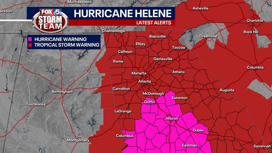
6 p.m. - The National Hurricane Center has extended the Hurricane Warning further north. Here are the current warnings:
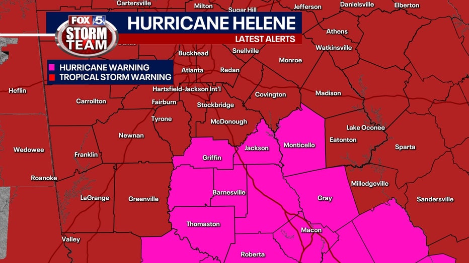
- A Hurricane Warning is in effect for Bibb, Bleckley, Butts, Chattahoochee, Crawford, Crisp, Dodge, Dooly, Houston, Jasper, Jones, Lamar, Laurens, Macon, Marion, Monroe, Muscogee, Peach, Pike, Pulaski, Schley, Spalding, Stewart, Sumter, Talbot, Taylor, Telfair, Twiggs, Upson, Webster, Wheeler, Wilcox, and Wilkinson
- A Tropical Storm Warning is in effect for Baldwin, Banks, Barrow, Bartow, Carroll, Catoosa, Chattooga, Cherokee, Clarke, Clayton, Cobb, Coweta, Dade, Dawson, DeKalb, Douglas, Emanuel, Fannin, Fayette, Floyd, Forsyth, Gilmer, Glascock, Gordon, Greene, Gwinnett, Hall, Hancock, Haralson, Harris, Heard, Henry, Jackson, Jefferson, Johnson, Lumpkin, Madison, Meriwether, Montgomery, Morgan, Murray, Newton, North Fulton, Oconee, Oglethorpe, Paulding, Pickens, Polk, Putnam, Rockdale, South Fulton, Taliaferro, Toombs, Towns, Treutlen, Troup, Union, Walker, Walton, Warren, Washington, White, Whitfield, and Wilkes
5:55 p.m. - The Rockdale County Sheriff's Office has issued a shelter in place advisory through Friday morning.
5:45 p.m. - The city of Atlanta has been spending the day clearing drains as heavy rains from Helene threaten to cause widespread flooding. READ MORE
5:42 p.m. - The Spalding County Sheriff's Office reports the following roadways are closed:
- Moon Rd Bridge
- 2217 Honeybee Creek Drive
- S McDonough @ Johnston (1-Lane)
- 164 S 6th St Ext (1-Lane)
- 108 Moose Lodge Rd
- 1054 County Line Rd
- E Maddox Rd
5:25 p.m. - Prepare your freezer and refrigerator now in case of a power outage. Here's how.
5:20 p.m. - West Georgia is getting ready to hunker down for Hurricane Helene. Watch the report.
5:15 p.m. - Residents in Cobb County are making their final runs to the store to stock up ahead of the storm. Watch the report.
5:10 p.m. - The Florida Panhandle is bracing for Hurricane Helene which is now racing towards the coast. Watch the report.
5 p.m. - Helene remains a powerful Category 3 storm, but is now racing towards the Florida Panhandle at 23 mph. The National Hurricane Center indicates the storm is strengthening. See the forecast below for full details.
4:30 p.m. - The FOX 5 Storm Team continues to track Hurricane Helene, a Category 3 storm. New data is expected to be released from the National Weather Service at 5 p.m. Stay with FOX 5 Atlanta for the latest.
4:11 p.m. - The Gulf Coast of Florida is being battered with high surf, strong winds, and storm surge as Hurricane Helene passes offshore. The latest from the Tampa Bay area.
3:18 p.m. - A separate Flash Flood Warning has been issued for Clayton, DeKalb, Fayette, Fulton, Gwinnett, and Henry counties until 9:15 p.m. Thursday. In those areas, FOX 5 Live VIPIR has been tracking a half-inch to 1.5 inches of rain with an additional 1 to 3 inches of rain expected in the next few hours.
3:11 p.m. - A Flash Flood Warning has been issued for Butts, Monroe, Fayette, Henry, Lamar, Pike, Spalding and Upson counties until 9:15 p.m. Thursday. FOX 5 Live VIPIR indicates between 1 and 1.5 inches of rain have already fallen in this area with another 1 to 3 inches of rain expected within the next few hours. Those living near waterways and other low-lying areas should be on alert. Those who need to be on the roadway should keep an eye out for street flooding.
3:06 p.m. - Kroger is reassuring residents that its stores are well-prepared to meet the community’s needs. READ MORE
2 p.m. - Hurricane Helene intensified to a Category 3 storm. Read below for the latest
1:34 p.m. - Gov. Brian Kemp and GEMA Director Chris Stallings held a press conference discussing the impending landfall of Hurricane Helene and its push into Georgia.
1:15 p.m. - Multiple Amtrak train routes are canceled for the day due to Helene, including those in Florida and Georgia. Customers with reservations on trains that are being modified will typically be accommodated on trains with similar departure times or another day. Amtrak will waive additional charges for customers looking to change their reservation during the modified schedule by calling our reservation center at 1-800-USA-RAIL.
12:58 p.m. - Fire departments in Gwinnett County are preparing for the possibility of swift water rescues. The storm is expected to bring record-breaking rainfall to the metro Atlanta area, and emergency crews are gearing up for the worst. READ MORE
12:46 p.m. - Residents across south Georgia are preparing for Hurricane Helene, which is expected to bring strong wind gusts and heavy rain later this evening. Emergency management officials from Valdosta to Atlanta are monitoring the situation closely as communities brace for the storm’s arrival. READ MORE
11:59 p.m. - Georgia Power and other utility companies across the state are preparing for outages. Here's how they are planning.
11:16 a.m. - President Joe Biden issued an emergency declaration for Georgia, ordering federal assistance to join the state and local emergency response teams effective from Tuesday to an undetermined future date. The president’s action allows the Department of Homeland Security and Federal Emergency Management Agency (FEMA), to coordinate disaster relief efforts and to provide help with emergency measures.
10:52 a.m. - A "sinkhole" opened on Thursday morning in a parking lot at Chinatown Mall in Chamblee. READ MORE
10:45 a.m. - Helene is expected to impact Delta’s hub at Hartsfield-Jackson Atlanta International Airport (ATL) as the storm moves north, potentially bringing tropical storm conditions to the Atlanta area. A travel waiver has been issued for customers traveling to or from several airports impacted by Helene, including ATL.
10:41 a.m. - Zoo Atlanta and several other Atlanta area attractions have announced they will close early on Thursday. Here's the full list.
9:31 a.m. - Flight disruptions are reported at Hartsfield-Jackson Atlanta International Airport and Tamapa International Airport.
What time is Helene supposed to hit land?
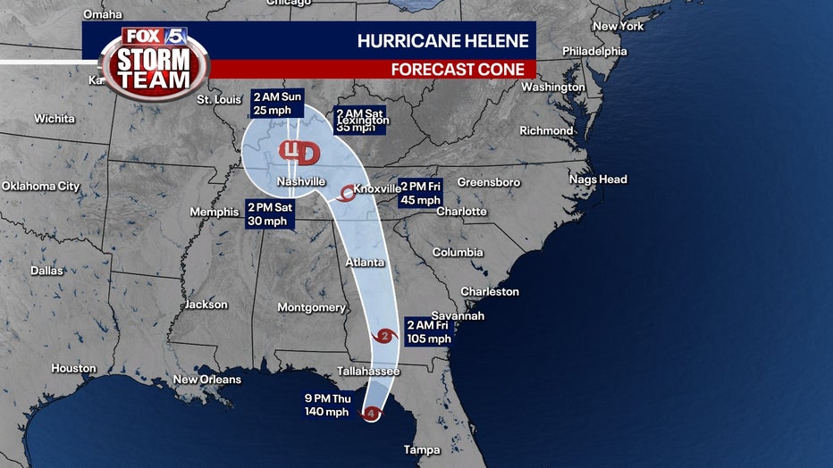
As of 2 a.m. on Friday, Helene was a Category 1 hurricane with maximum sustained winds of 90 mph. The storm was about 30 miles north of Valdosta, moving north-northeast at 26 mph, the National Hurricane Center said.
Hurricane force winds extend 30 miles from the center and tropical storm-force winds extend out 310 miles.
SEE ALSO: Wednesday's storms small taste of Hurricane Helene in Georgia
For Atlanta, Helene could be the worst strike on a major Southern inland city in 35 years, said University of Georgia meteorology professor Marshall Shepherd. The damage could be greater due to an unrelated severe storm that knocked down trees, blocking roads and taking down power lines on Wednesday. Parts of the metro Atlanta area have already seen 2 to 5 inches of rain in the last 24 hours, leading to higher threats of flooding.
Tropical Storm Warning for metro Atlanta
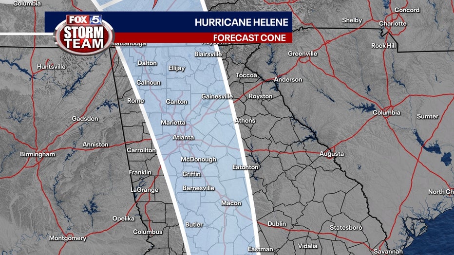
As of 2 a.m. Friday, Hurricane Helene was 185 miles south of Atlanta.
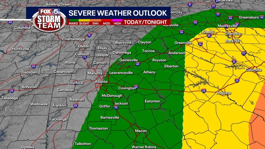
Warnings are in effect statewide for Hurricane Helene as it intensifies, with a particular focus on central and northern Georgia, including the Atlanta metro area. Helene is expected to make landfall as a major Category 3 hurricane, potentially strengthening further over the Gulf of Mexico, posing significant threats to life and property in the region.
Here is a comprehensive update on the expected impacts, timing, and preparedness measures for Atlanta and North Georgia.
Tropical Storm and Hurricane Warnings
- Tropical Storm Warning: Portions of central and northern Georgia, including Atlanta, are under a Tropical Storm Warning. Wind gusts of 39 to 70 mph are expected within the next 36 hours.
- Hurricane Warning: Portions of Middle and Southwestern Georgia is under a Hurricane Warning, with expected wind gusts of 74 mph or higher, also within the next 36 hours. This area will experience the most severe conditions as Helene moves inland.
Helene will arrive in southern Georgia overnight as a strong hurricane before weakening to a tropical storm as it climbs northward overnight Thursday into Friday morning. Calmer and drier conditions will emerge by Friday afternoon across the region.
Key impacts:
- Winds: Sustained tropical storm-force winds will likely affect much of central and northern Georgia, with the Atlanta metro area expected to see gusts up to 70 mph. Although these gusts will be intermittent, they pose a serious danger due to the risk of downed trees and power outages. NWS has highlighted a very high risk for widespread and extended outages, especially in areas where the ground has already been saturated by previous rainfall. Tropical storm-force winds are most likely to begin around 3 a.m. on Friday across the Atlanta metro.
- Rainfall and Flooding: Heavy rain, with totals ranging from 3 to 6 inches across much of the region, will exacerbate flash flooding concerns. Heavy rainfall is expected to enhance flash flooding risks, especially across major roadways like the I-85 corridor and the foothills of the North Georgia mountains. Urban areas in Atlanta, with limited drainage, could see street flooding, road closures, and widespread disruption.
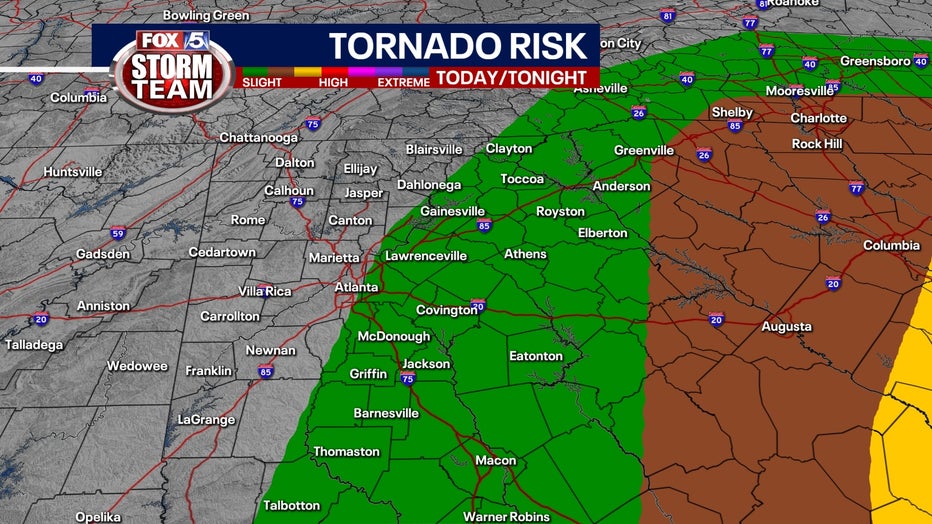
- Tornadoes: There is a heightened risk of tornadoes in southeast Georgia, where the most severe storm conditions are forecast.
Preparedness and Action Steps
Residents across central and northern Georgia are urged to take immediate action:
- Secure Outdoor Objects: Bring in or secure items that can become projectiles in high winds.
- Monitor Flood Alerts: Stay informed on flash flood warnings and avoid traveling through flooded roadways.
- Power Outages: Prepare for extended power outages by gathering supplies, including water, non-perishable food, and batteries.
- Stay Informed: Get continuous updates on the FOX 5 Storm Team Weather App, FOX Local streaming app, on our website and on the air.

Helene emergency resources
Helene is the eighth named storm of the Atlantic hurricane season, which runs from June 1 to Nov. 30.
The National Oceanic and Atmospheric Administration has predicted an above-average Atlantic hurricane season this year because of record-warm ocean temperatures. It forecasts 17 to 25 named storms, with four to seven major hurricanes of Category 3 or higher.
Here are som additional resources:
- Hurricane Helene cancelations/closings in metro Atlanta, North Georgia
- What to do if your home or vehicle is flooded because of Hurricane Helene
- What to do if your home was damaged by Hurricane Helene
- How to keep electronics charged if power goes out
- Outage maps, emergency shelters, emergency management agencies
- A complete guide to hurricane preparedness
- Mobilizing to help unhoused ahead of storm
- Dozens of dogs need temporary homes as storm approaches
- Here’s how to prepare for severe storms, power outages
- How to protect your pets during hurricanes, severe weather
- Be ready for possible flooding
- Hurricane Helene Timeline: When can we expect to feel the impact in Georgia?
Watch vs. warning: Knowing the difference
In the world of meteorology, terms like "watch" and "warning" are commonplace.
A "watch" indicates the potential for a significant weather event, such as tornadoes, severe thunderstorms, floods, or winter conditions. It means that the ingredients for dangerous weather are present, and it could develop shortly. National Weather Service experts emphasize that a watch serves as a preparatory alert, encouraging individuals to stay informed and to devise safety plans in case conditions worsen.
On the other hand, a "warning" is far more urgent. It confirms that the perilous weather is either happening or imminent, based on sightings or radar evidence. Warnings signal a time to take immediate action to protect life and property. Whether it's taking shelter during a tornado warning or moving to higher ground during a flood warning, the response should be swift and decisive.
A third term, "advisory" may be issued to give a heads up about a weather event but does not rise to the criteria of the other two.
Meteorologists stress the importance of recognizing these alerts, as they are designed to provide timely information that can prevent loss of life and minimize injury. There are multiple ways to receive alerts — such as weather apps, radios, or text alerts — and to always err on the side of caution when these notices are issued.
KEEP UP WITH THE LATEST BY DOWNLOADING THE FREE FOX 5 STORM TEAM APP AND FOLLOWING @FOX5STORMTEAM ON X, FORMERLY TWITTER
Atlanta weather: School closings
Hurricane Helene is impacting schools and businesses. Several high schools are opting to move their Friday football games. Multiple school districts have opted to go virtual.
Atlanta and Fulton County schools have both closed schools on Thursday and Friday.
FOX 5 has a full list of closings, delays, and cancelations here.
SEE ALSO:
- JD Vance postpones Georgia campaign stops due to Hurricane Helene
- Atlanta Braves games Wednesday, Thursday postponed due to threat of Helene
Atlanta airport weather delays
In Atlanta, there is the possibility that Helene will impact operations at Hartsfield-Jackson Atlanta International Airport, which could create a ripple effect on travel across the country.
Tampa International Airport is expected to close at 2 a.m. Thursday, but it is not clear if Atlanta will officially close.
Delta Air Lines says any rebooking made before Oct. 1 due to Helene will have the booking fee waived. Tickets must have been purchased prior to Sept. 25, 2024.
Georgia Power crews mobilizing
Georgia Power is getting ready to handle the imminent power outages. Officials shared how they are mobilizing and gearing up.
"They will see where the storm is going and they will be able to dispatch crews to the appropriate places where the outages are to get back on first," said spokesperson Matthew Kent.
He says crews are ready to face whatever Hurricane Helene brings to the state.
"The most important thing we will be doing in the next 48 hours is we will be stationing our crews throughout the state. Many of them are already at headquarters throughout the state but we want to make sure they are in the right place to respond as quickly as possible," Kent said.
He says while his crews get ready to deal with the aftermath, now is the time to prepare your family and home
"Having enough supplies to maintain yourself. Having food and water and medication. All important things to have just in case the power goes out," Kent said.
Other things to do is to charge cell phones, buy extra batteries, flashlights, and non-perishable items in case of power outage.
"If your power does go out and you want to use a gas generator make sure you place it outside. It is an engine and it's producing fumes, so you don't want to have that inside," Kent said.
The most important thing is to never approach downed lines.
"Stay away from downed power lines. If it's on a fence or in debris they can still have energy flowing through the fence or debris," Kent said.
Atlanta preparing for Helene
As Hurricane Helene approaches, Atlanta Mayor Andre Dickens announced that all nonessential city employees will be working from home through the end of the week. The city is bracing for heavy rainfall and potential flooding, with public safety agencies and public works crews on high alert.
"We want to assure our residents, businesses, and visitors that preparations are well underway in Atlanta to deal with Hurricane Helene," Dickens said during a media briefing on Wednesday afternoon.
The Atlanta Police Department, in partnership with Wellstar, has been working to inform unhoused residents about the storm, with overflow shelters planned at Selena Butler Recreation Center, Old Adamsville Recreation Center, and Central Park Recreation Center if necessary. The city is also taking steps to assist its senior population ahead of the storm.
Transportation workers are actively clearing storm drains to prevent flooding, while firefighters are preparing for potential water rescues. Crews are also on standby to remove fallen trees. In addition, all parks and recreation activities have been canceled through the end of the week.
Public works and watershed management teams have been working proactively to clear storm drains and monitor areas prone to flooding. The city’s ATL 311 line will begin operating outside of normal business hours, starting at midnight, to assist residents.
Local municipalities across Metro Atlanta are also preparing for the storm. Forest Park, which is under a Tropical Storm Warning, is taking precautions. "Your public safety staff—police and fire—are ready to respond to any incident," said Forest Park Fire Chief Latosha Clemons. "We’re ready to respond to our community."
For emergency alerts, Atlanta residents can text "Atlnotify" to 24639.
Hurricane Helene preps in south Georgia
It’s a race against time in south Georgia As residents make their last minute preparations ahead of Hurricane Helene.
"I’ve been in so many of them. So, what I'm doing is preparing," said Valdosta resident, James Mobley.
"It's going to be a massive storm. So, we can only brace for what's about to come," said AJ Duplessis, who just moved to Valdosta.
Duplessis packed sandbags in Valdosta on Wednesday to prepare for possible flooding. He’s no stranger to tropical trouble after living in Louisiana and Florida. He moved to Valdosta this month and he’s not taking any chances.
"You never know what may occur, despite of the category of the hurricanes, you never know how things may occur. So, you always want to be prepared," he said.
The Georgia Emergency Management Agency warns that all of Georgia's 159 counties need to be on alert.
"We're really worried about the wind threat and the potential to see hurricane-force winds as it comes into the south, into the county," said Meghan Barwick, Lowndes County EMA.
That strong wind means Valdosta is preparing for widespread power outages. While this area is no stranger to storms, officials are urging everyone here to stock up on food and supplies to be ready.
"We've had Hurricane Adelia on August 30 of 2023. We had Hurricane Debby just a month ago, and now we have Hurricane Helene. So, our community is really reeling from these storms," Barwick said.
Many in this community are heeding the warnings and aren’t taking this storm lightly.
"Stocked up on everything. I'm prepared. I got water, I got food, you know, and like I said, I got a generator. So, I'm prepared. It's not my first hurricane," said Mobley.
GEMA prepares for Helene's impact on Georgia
As Hurricane Helene strengthens and nears landfall in Florida, Georgia officials are urging residents to finalize preparations, warning the storm will impact all 159 counties. The Georgia Emergency Management and Homeland Security Agency (GEMA) stressed that the storm is moving faster than anticipated, shortening the time left to prepare.
GEMA Director Chris Stallings highlighted the urgency. "The timeline for everybody has been sped up. After tomorrow, you need to be prepared to hunker and shelter in place," he said.
On Wednesday, GEMA officials provided an updated forecast for Helene, which is now expected to cross into Georgia as a Category 3 hurricane, with southern and central regions under hurricane warnings. Heavy rain, flash flooding, tornados, and widespread power outages are anticipated.
"We’re going to see some significant power outages, probably nothing like we’ve seen," Stallings warned. He noted that the storm's forward speed had increased to over 25 mph, compounding the risk. "We had reports of a tornado that touched down in Habersham from this particular event, and we’ve already seen some power outages around the state…about 6,000 customers in Habersham."
In addition to tornadoes and power outages, mudslides in north Georgia and flash flooding statewide remain significant concerns. Stallings also announced that the Georgia National Guard will deploy 250 guardsmen on Thursday, and an emergency response center has been established in Macon.
Georgia issues State of Emergency
Gov. Brian Kemp issued a state of emergency on Tuesday, allowing state agencies to deploy resources as needed. "The current forecast for Hurricane Helene suggests this storm will impact every part of our state," Kemp said. "We are not taking anything for granted, which is why I have directed appropriate state agencies to work around the clock."
Stallings echoed Kemp's call for preparation. "It is not safe to be out…it is extremely dangerous as we’ve seen through some of these storms the impact of what limbs and rocks and debris can do to somebody. Unfortunately, the majority of our loss of life during these events are trees falling on cars," he said.
GEMA advises residents to prepare for at least 72 hours without power. Stallings urged residents to charge devices, prepare emergency kits, and have plans in place to shelter in place. "Once the storm gets to you, you need to shelter in place," he said, adding that basements are the safest option, and vehicles do not provide adequate shelter.