

An overview of geospatial methods used in unintentional injury epidemiology
- PMID: 28018997
- PMCID: PMC5183571
- DOI: 10.1186/s40621-016-0097-0
An overview of geospatial methods used in unintentional injury epidemiology
Abstract
Background: Injuries are a leading cause of death and disability around the world. Injury incidence is often associated with socio-economic and physical environmental factors. The application of geospatial methods has been recognised as important to gain greater understanding of the complex nature of injury and the associated diverse range of geographically-diverse risk factors. Therefore, the aim of this paper is to provide an overview of geospatial methods applied in unintentional injury epidemiological studies.
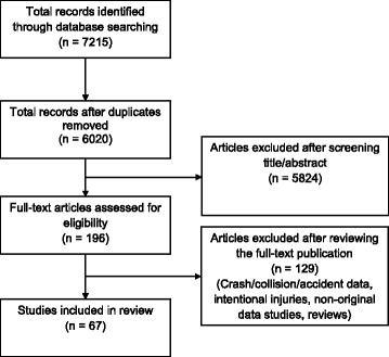
Methods: Nine electronic databases were searched for papers published in 2000-2015, inclusive. Included were papers reporting unintentional injuries using geospatial methods for one or more categories of spatial epidemiological methods (mapping; clustering/cluster detection; and ecological analysis). Results describe the included injury cause categories, types of data and details relating to the applied geospatial methods.
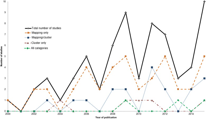
Results: From over 6,000 articles, 67 studies met all inclusion criteria. The major categories of injury data reported with geospatial methods were road traffic (n = 36), falls (n = 11), burns (n = 9), drowning (n = 4), and others (n = 7). Grouped by categories, mapping was the most frequently used method, with 62 (93%) studies applying this approach independently or in conjunction with other geospatial methods. Clustering/cluster detection methods were less common, applied in 27 (40%) studies. Three studies (4%) applied spatial regression methods (one study using a conditional autoregressive model and two studies using geographically weighted regression) to examine the relationship between injury incidence (drowning, road deaths) with aggregated data in relation to explanatory factors (socio-economic and environmental).
Conclusion: The number of studies using geospatial methods to investigate unintentional injuries has increased over recent years. While the majority of studies have focused on road traffic injuries, other injury cause categories, particularly falls and burns, have also demonstrated the application of these methods. Geospatial investigations of injury have largely been limited to mapping of data to visualise spatial structures. Use of more sophisticated approaches will help to understand a broader range of spatial risk factors, which remain under-explored when using traditional epidemiological approaches.
Keywords: Cluster detection; Clustering; Ecological analysis; Geographical correlation; Geographical epidemiology; Mapping; Smoothing; Spatial analysis; Spatial epidemiology.
Figures
Similar articles
-
Potential for establishing an injury surveillance system in India: a review of data sources and reporting systems.BMC Public Health. 2020 Dec 14;20(1):1909. doi: 10.1186/s12889-020-09992-9. BMC Public Health. 2020. PMID: 33317493 Free PMC article. Review.
-
Injuries as a public health problem in sub-Saharan Africa: epidemiology and prospects for control.East Afr Med J. 2000 Dec;77(12 Suppl):S1-43. East Afr Med J. 2000. PMID: 12862115
-
Call for more research on injury from the developing world: results of a bibliometric analysis.Indian J Med Res. 2009 Mar;129(3):321-6. Indian J Med Res. 2009. PMID: 19491427
-
Child unintentional injury prevention in Eastern Mediterranean Region.Int J Crit Illn Inj Sci. 2016 Jan-Mar;6(1):33-9. doi: 10.4103/2229-5151.177366. Int J Crit Illn Inj Sci. 2016. PMID: 27051620 Free PMC article.
-
Effective interventions for unintentional injuries: a systematic review and mortality impact assessment among the poorest billion.Lancet Glob Health. 2018 May;6(5):e523-e534. doi: 10.1016/S2214-109X(18)30107-4. Lancet Glob Health. 2018. PMID: 29653626 Review.
Cited by
-
Mapping Child Safety Seat Use in Cases of Fatal or Incapacitating Child Motor Vehicle Injury in Cook County, Illinois from 2011 to 2015.J Community Health. 2019 Jun;44(3):605-609. doi: 10.1007/s10900-019-00626-9. J Community Health. 2019. PMID: 30796584
-
Advancing health equity and access using telemedicine: a geospatial assessment.J Am Med Inform Assoc. 2019 Aug 1;26(8-9):796-805. doi: 10.1093/jamia/ocz108. J Am Med Inform Assoc. 2019. PMID: 31340022 Free PMC article.
-
Spatiotemporal mapping of major trauma in Victoria, Australia.PLoS One. 2022 Jul 6;17(7):e0266521. doi: 10.1371/journal.pone.0266521. eCollection 2022. PLoS One. 2022. PMID: 35793336 Free PMC article.
-
Enrichment of a Data Lake to Support Population Health Outcomes Studies Using Social Determinants Linked EHR Data.AMIA Jt Summits Transl Sci Proc. 2023 Jun 16;2023:448-457. eCollection 2023. AMIA Jt Summits Transl Sci Proc. 2023. PMID: 37350893 Free PMC article.
-
Area-Level Variation and Human Papillomavirus Vaccination among Adolescents and Young Adults in the United States: A Systematic Review.Cancer Epidemiol Biomarkers Prev. 2021 Jan;30(1):13-21. doi: 10.1158/1055-9965.EPI-20-0617. Epub 2020 Oct 2. Cancer Epidemiol Biomarkers Prev. 2021. PMID: 33008874 Free PMC article.
References
-
- Anselin L. Local indicators of spatial association—LISA. Geogr Anal. 1995;27(2):93–115. doi: 10.1111/j.1538-4632.1995.tb00338.x. - DOI
-
- Anselin L, Syabri I, Kho Y. GeoDa: an introduction to spatial data analysis. Geogr Anal. 2006;38(1):5–22. doi: 10.1111/j.0016-7363.2005.00671.x. - DOI
-
- Bamzar R, Ceccato V. The nature and the geography of elderly injuries in Sweden. GeoJournal. 2015;80(2):279–299. doi: 10.1007/s10708-014-9552-z. - DOI
Publication types
LinkOut - more resources
Full Text Sources
Other Literature Sources
Miscellaneous
