

Rabies outbreak in Greece during 2012-2014: use of Geographical Information System for analysis, risk assessment and control
- PMID: 27435434
- PMCID: PMC9150405
- DOI: 10.1017/S0950268816001527
Rabies outbreak in Greece during 2012-2014: use of Geographical Information System for analysis, risk assessment and control
Abstract
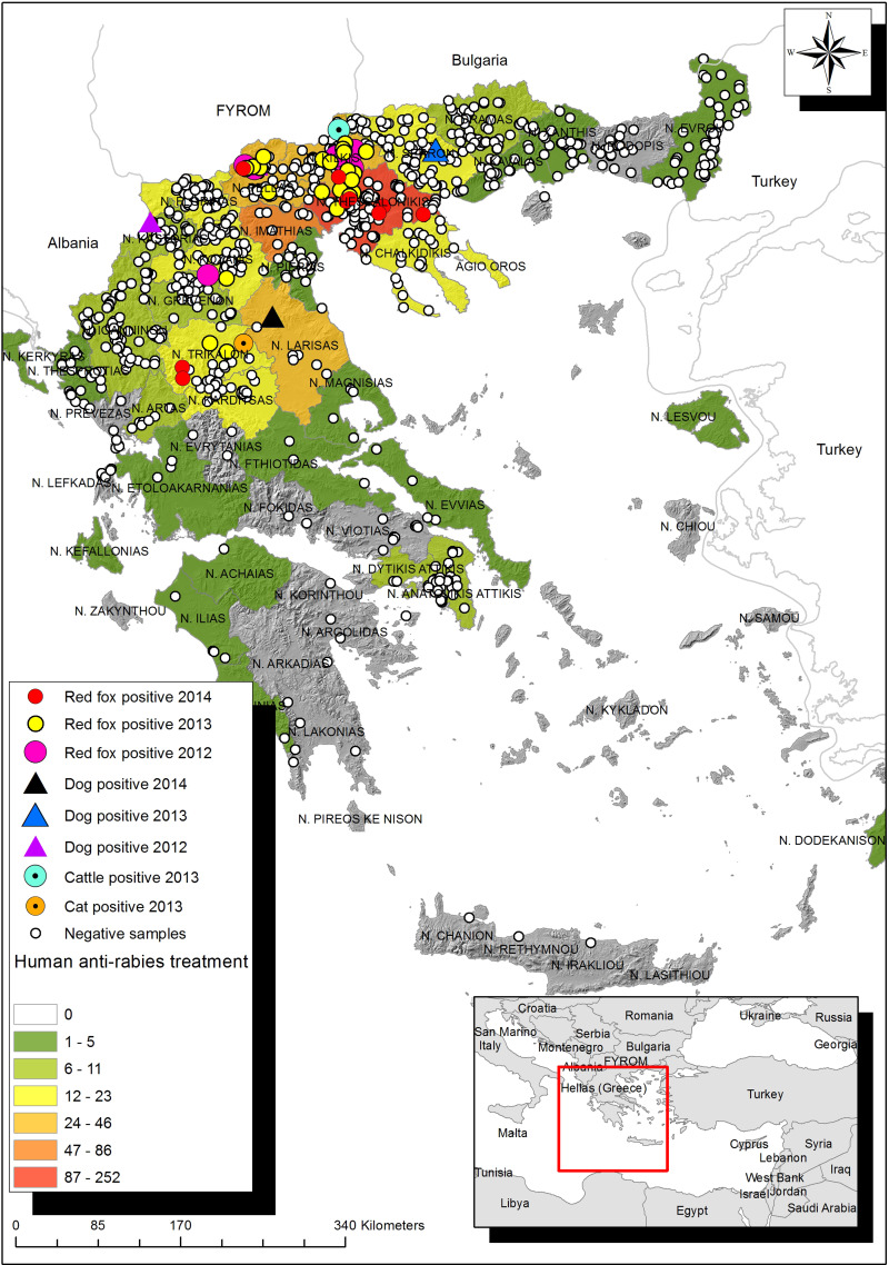
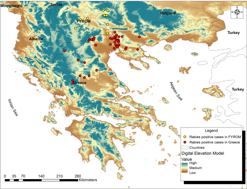
The objectives of this work were (i) geographical analysis of the 2012-2014 outbreak of rabies in Greece using GIS and (ii) comparative analysis of animal cases with data of potential human exposure to rabies together with environmental data, in order to provide information for risk assessment, effective monitoring and control. Most animal cases (40/48) involved red foxes, while domestic animals were also diagnosed with rabies. Overall, 80% of the cases were diagnosed in central northern Greece; 75% of the cases were diagnosed in low altitudes (<343·5 m), within a distance of 1 km from human settlements. Median distance from livestock farms was 201·25 m. Most people potentially exposed to rabies (889/1060) presented with dog bite injuries. Maximum entropy analysis revealed that distance from farms contributed the highest percentage in defining environmental niche profiles for rabid foxes. Oral vaccination programmes were implemented in 24 administrative units of the country during 2013 and 2014, covering a total surface area of ~60 000 km2. Rabies re-occurrence in Greece emphasizes the need for ongoing surveillance in cross-border areas and in areas with intense human activity.
Keywords: Fox; Geographical Information System; Greece; rabies.
Figures
Similar articles
-
Re-emergence of animal rabies in northern Greece and subsequent human exposure, October 2012 - March 2013.Euro Surveill. 2013 May 2;18(18):20474. Euro Surveill. 2013. PMID: 23725773
-
Rabies surveillance in the United States during 2006.J Am Vet Med Assoc. 2007 Aug 15;231(4):540-56. doi: 10.2460/javma.231.4.540. J Am Vet Med Assoc. 2007. PMID: 17696853
-
Rabies surveillance in the United States during 2007.J Am Vet Med Assoc. 2008 Sep 15;233(6):884-97. doi: 10.2460/javma.233.6.884. J Am Vet Med Assoc. 2008. PMID: 18795848
-
Rabies surveillance in the United States during 2001.J Am Vet Med Assoc. 2002 Dec 15;221(12):1690-701. doi: 10.2460/javma.2002.221.1690. J Am Vet Med Assoc. 2002. PMID: 12494966 Review.
-
Rabies surveillance in the United States during 1996.J Am Vet Med Assoc. 1997 Dec 15;211(12):1525-39. J Am Vet Med Assoc. 1997. PMID: 9412679 Review.
Cited by
-
Patterns of animal rabies in the Nizhny Novgorod region of Russia (2012-2022): the analysis of risk factors.Front Vet Sci. 2024 Oct 22;11:1440408. doi: 10.3389/fvets.2024.1440408. eCollection 2024. Front Vet Sci. 2024. PMID: 39502946 Free PMC article.
-
Knowledge, Attitude and Practices (KAP) of Ruminant Livestock Farmers Related to Zoonotic Diseases in Elassona Municipality, Greece.Eur J Investig Health Psychol Educ. 2022 Feb 25;12(3):269-280. doi: 10.3390/ejihpe12030019. Eur J Investig Health Psychol Educ. 2022. PMID: 35323205 Free PMC article.
-
Update on lyssaviruses and rabies: will past progress play as prologue in the near term towards future elimination?Fac Rev. 2020 Nov 16;9:9. doi: 10.12703/b/9-9. eCollection 2020. Fac Rev. 2020. PMID: 33659941 Free PMC article. Review.
-
Approaches for disease prioritization and decision-making in animal health, 2000-2021: a structured scoping review.Front Vet Sci. 2023 Oct 6;10:1231711. doi: 10.3389/fvets.2023.1231711. eCollection 2023. Front Vet Sci. 2023. PMID: 37876628 Free PMC article.
References
-
- Cliquet F, Aubert M. Elimination of terrestrial rabies in Western European countries. Developments in Biologicals 2004; 119: 185–204. - PubMed
-
- Bourhy H, et al. Ecology and evolution of rabies virus in Europe. Journal of General Virology 1999; 80: 2545–2557. - PubMed
-
- McElhinney LM, et al. Molecular diversity and evolutionary history of rabies virus strains circulating in the Balkans. Journal of General Virology 2011; 92: 2171–2180. - PubMed
-
- Picard-Meyer E, et al. Molecular characterisation of rabies virus strains in the Republic of Macedonia. Archives of Virology 2013; 158: 237–240. - PubMed
Publication types
MeSH terms
Substances
LinkOut - more resources
Full Text Sources
Other Literature Sources
Medical
