

High heterogeneity in Plasmodium falciparum risk illustrates the need for detailed mapping to guide resource allocation: a new malaria risk map of the Lao People's Democratic Republic
- PMID: 20181273
- PMCID: PMC2841197
- DOI: 10.1186/1475-2875-9-59
High heterogeneity in Plasmodium falciparum risk illustrates the need for detailed mapping to guide resource allocation: a new malaria risk map of the Lao People's Democratic Republic
Abstract
Background: Accurate information on the geographical distribution of malaria is important for efficient resource allocation. The Lao People's Democratic Republic has experienced a major decline in malaria morbidity and mortality in the past decade. However, efforts to respond effectively to these changes have been impeded by lack of detailed data on malaria distribution. In 2008, a countrywide survey on Plasmodium falciparum diagnosed in health centres and villages was initiated to develop a detailed P. falciparum risk map with the aim to identify priority areas for malaria control, estimate population at risk, and guide resource allocation in the Lao People's Democratic Republic.
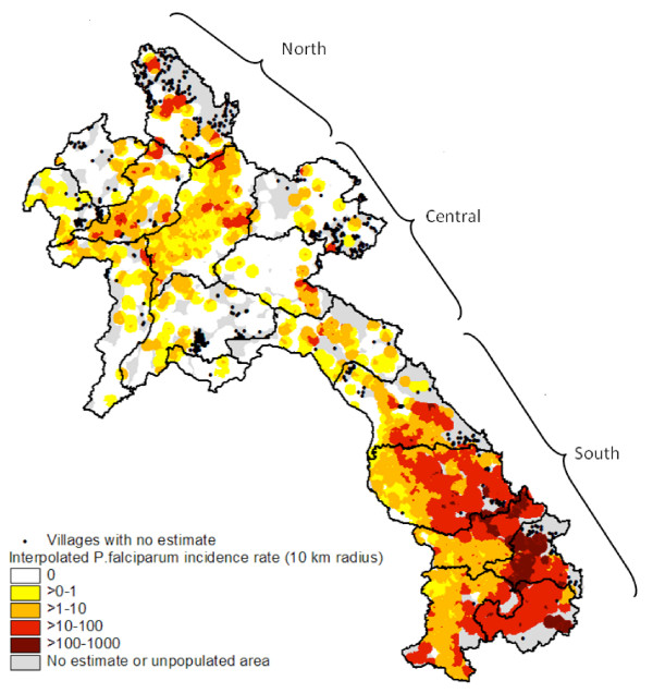
Methods: P. falciparum incidence data were collected from point-referenced villages and health centres for the period 2006-2008 during a country-wide survey between December 2008 and January 2009. Using the highest recorded annual rate, continuous surfaces of P. falciparum incidence were produced by the inverse distance weighted interpolation technique.
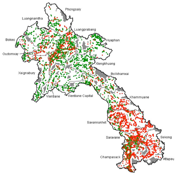
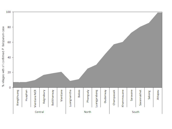
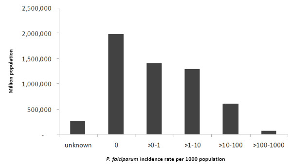
Results: Incidence rates were obtained from 3,876 villages and 685 health centres. The risk map shows that P. falciparum is highly heterogeneous in the northern and central regions of the country with large areas of no transmission. In the southern part, transmission is pervasive and the risk of P. falciparum is high. It was estimated that 3.4 million people (60% of the population) live at risk of malaria.
Conclusions: This paper presents the first comprehensive malaria risk map of the Lao People's Democratic Republic based entirely on empirical data. The estimated population at risk is substantially lower than previous estimates, reflecting the presence of vast areas with focal or no malaria transmission as identified in this study. These findings provide important guidance for malaria control interventions in the Lao People's Democratic Republic, and underline the need for detailed data on malaria to accurately predict risk in countries with heterogeneous transmission.
Figures
Similar articles
-
Asymptomatic malaria, growth status, and anaemia among children in Lao People's Democratic Republic: a cross-sectional study.Malar J. 2016 Oct 18;15(1):499. doi: 10.1186/s12936-016-1548-3. Malar J. 2016. PMID: 27756399 Free PMC article.
-
Spatio-temporal associations between deforestation and malaria incidence in Lao PDR.Elife. 2021 Mar 9;10:e56974. doi: 10.7554/eLife.56974. Elife. 2021. PMID: 33686939 Free PMC article.
-
Dengue-like illness surveillance: a two-year longitudinal survey in suburban and rural communities in the Lao People's Democratic Republic and in Thailand.Western Pac Surveill Response J. 2019 Feb 19;10(1):15-24. doi: 10.5365/wpsar.2017.8.4.001. eCollection 2019 Jan-Mar. Western Pac Surveill Response J. 2019. PMID: 31110838 Free PMC article.
-
Private sector opportunities and threats to achieving malaria elimination in the Greater Mekong Subregion: results from malaria outlet surveys in Cambodia, the Lao PDR, Myanmar, and Thailand.Malar J. 2017 May 2;16(1):180. doi: 10.1186/s12936-017-1800-5. Malar J. 2017. PMID: 28464945 Free PMC article. Review.
-
Schistosoma mekongi in Cambodia and Lao People's Democratic Republic.Adv Parasitol. 2010;72:179-203. doi: 10.1016/S0065-308X(10)72007-8. Adv Parasitol. 2010. PMID: 20624532 Review.
Cited by
-
Mapping the aetiology of non-malarial febrile illness in Southeast Asia through a systematic review--terra incognita impairing treatment policies.PLoS One. 2012;7(9):e44269. doi: 10.1371/journal.pone.0044269. Epub 2012 Sep 6. PLoS One. 2012. PMID: 22970193 Free PMC article. Review.
-
A Repeat Random Survey of the Prevalence of Falsified and Substandard Antimalarials in the Lao PDR: A Change for the Better.Am J Trop Med Hyg. 2015 Jun;92(6 Suppl):95-104. doi: 10.4269/ajtmh.15-0057. Epub 2015 Apr 20. Am J Trop Med Hyg. 2015. PMID: 25897062 Free PMC article.
-
Malaria prevalence, knowledge, perception, preventive and treatment behavior among military in Champasak and Attapeu provinces, Lao PDR: a mixed methods study.Trop Med Health. 2019 Jan 25;47:11. doi: 10.1186/s41182-019-0138-9. eCollection 2019. Trop Med Health. 2019. PMID: 30700970 Free PMC article.
-
Fine-scale maps of malaria incidence to inform risk stratification in Laos.Malar J. 2024 Jun 25;23(1):196. doi: 10.1186/s12936-024-05007-9. Malar J. 2024. PMID: 38918779 Free PMC article.
-
Targeting asymptomatic malaria infections: active surveillance in control and elimination.PLoS Med. 2013;10(6):e1001467. doi: 10.1371/journal.pmed.1001467. Epub 2013 Jun 18. PLoS Med. 2013. PMID: 23853551 Free PMC article.
References
-
- Ceccato P, Ghebremeskel T, Jaiteh M, Graves PM, Levy M, Ghebreselassie S, Ogbamariam A, Barnston AG, Bell M, del Corral J, Connor SJ, Fesseha I, Brantly EP, Thomson MC. Malaria stratification, climate, and epidemic early warning in Eritrea. Am J Trop Med Hyg. 2007;77:61–68. - PubMed
Publication types
MeSH terms
LinkOut - more resources
Full Text Sources
Miscellaneous
