

Micro-geographic risk factors for malarial infection
- PMID: 19216781
- PMCID: PMC2649150
- DOI: 10.1186/1475-2875-8-27
Micro-geographic risk factors for malarial infection
Abstract
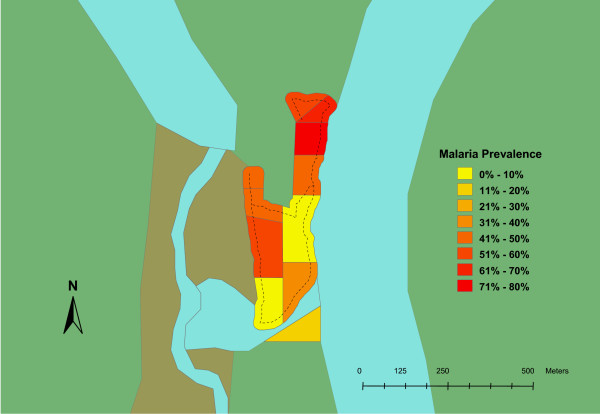
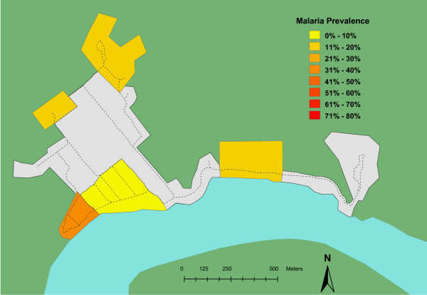
Background: Knowledge of geography is integral to the study of insect-borne infectious disease such as malaria. This study was designed to evaluate whether geographic parameters are associated with malarial infection in the East Sepik province of Papua New Guinea (PNG), a remote area where malaria is a major cause of morbidity and mortality.
Methods: A global positioning system (GPS) unit was used at each village to collect elevation, latitude and longitude data. Concurrently, a sketch map of each village was generated and the villages were sub-divided into regions of roughly equal populations. Blood samples were taken from subjects in each region using filter paper collection. The samples were later processed using nested PCR for qualitative determination of malarial infection. The area was mapped using the GPS-information and overlaid with prevalence data. Data tables were examined using traditional chi square statistical techniques. A logistic regression analysis was then used to determine the significance of geographic risk factors including, elevation, distance from administrative centre and village of residence.
Results: Three hundred and thirty-two samples were included (24% of the total estimated population). Ninety-six were positive, yielding a prevalence of 29%. Chi square testing within each village found a non-random distribution of cases across sub-regions (p < 0.05). Multivariate logistic regression techniques suggested malarial infection changed with elevation (OR = 0.64 per 10 m, p < 0.05) and distance from administrative centre (OR = 1.3 per 100 m, p < 0.05).
Conclusion: These results suggest that malarial infection is significantly and independently associated with lower elevation and greater distance from administrative centre in a rural area in PNG. This type of analysis can provide information that may be used to target specific areas in developing countries for malaria prevention and treatment.
Figures
Similar articles
-
Malaria infections are randomly distributed in diverse holoendemic areas of Papua New Guinea.Am J Trop Med Hyg. 2002 Dec;67(6):555-62. doi: 10.4269/ajtmh.2002.67.555. Am J Trop Med Hyg. 2002. PMID: 12518843 Free PMC article.
-
A survey of malarial infection in endemic areas of Savannakhet province, Lao PDR and comparative diagnostic efficiencies of Giemsa staining, acridine orange staining, and semi-nested multiplex PCR.Parasitol Int. 2008 Jun;57(2):143-9. doi: 10.1016/j.parint.2007.11.003. Epub 2007 Nov 24. Parasitol Int. 2008. PMID: 18160336
-
Changing patterns of Plasmodium blood-stage infections in the Wosera region of Papua New Guinea monitored by light microscopy and high throughput PCR diagnosis.Am J Trop Med Hyg. 2006 Oct;75(4):588-96. Am J Trop Med Hyg. 2006. PMID: 17038678 Free PMC article.
-
Cross-species regulation of malaria parasitaemia in the human host.Curr Opin Microbiol. 2002 Aug;5(4):431-7. doi: 10.1016/s1369-5274(02)00348-x. Curr Opin Microbiol. 2002. PMID: 12160865 Review.
-
Assembling a global database of malaria parasite prevalence for the Malaria Atlas Project.Malar J. 2007 Feb 16;6:17. doi: 10.1186/1475-2875-6-17. Malar J. 2007. PMID: 17306022 Free PMC article. Review.
Cited by
-
Geographic information system (GIS) maps and malaria control monitoring: intervention coverage and health outcome in distal villages of Khammouane province, Laos.Malar J. 2009 Sep 22;8:217. doi: 10.1186/1475-2875-8-217. Malar J. 2009. PMID: 19772628 Free PMC article.
-
High heterogeneity in Plasmodium falciparum risk illustrates the need for detailed mapping to guide resource allocation: a new malaria risk map of the Lao People's Democratic Republic.Malar J. 2010 Feb 24;9:59. doi: 10.1186/1475-2875-9-59. Malar J. 2010. PMID: 20181273 Free PMC article.
-
The epidemiology of Plasmodium falciparum and Plasmodium vivax in East Sepik Province, Papua New Guinea, pre- and post-implementation of national malaria control efforts.Malar J. 2020 Jun 5;19(1):198. doi: 10.1186/s12936-020-03265-x. Malar J. 2020. PMID: 32503607 Free PMC article.
-
Tackling the malaria problem in the South-East Asia Region: need for a change in policy?Indian J Med Res. 2013 Jan;137(1):36-47. Indian J Med Res. 2013. PMID: 23481050 Free PMC article.
-
Elevated dry-season malaria prevalence associated with fine-scale spatial patterns of environmental risk: a case-control study of children in rural Malawi.Malar J. 2013 Nov 11;12:407. doi: 10.1186/1475-2875-12-407. Malar J. 2013. PMID: 24206777 Free PMC article.
References
-
- Cattani JA, Moir JS, Gibson FD, Ginny M, Paino J, Davidson W, Alpers MP. Small-area variations in the epidemiology of malaria in Madang Province. 1986. P N G Med J. 2005;48:95–101. - PubMed
-
- Thompson R, Begtrup K, Cuamba N, Dgedge M, Mendis C, Gamage-Mendis A, Enosse SM, Barreto J, Sinden RE, Hogh B. The Matola malaria project: a temporal and spatial study of malaria transmission and disease in a suburban area of Maputo, Mozambique. Am J Trop Med Hyg. 1997;57:550–559. - PubMed
-
- World Health Statistics 2006. Geneva, Switzerland: World Health Organization; 2006.
-
- Kottek M, Greiser J, Beck C, Rudolf B, Rubel F. World Map of the Köppen-Geiger climate classification updated. Meteorol Z. 2006;15:259–263. doi: 10.1127/0941-2948/2006/0130. - DOI
Publication types
MeSH terms
Substances
LinkOut - more resources
Full Text Sources
Medical
